 Filter: Categories of Wisconsin Historical Images
Filter: FULL_DATE of 1915
Filter: Subject of michigan, lake
Filter: Categories of Wisconsin Historical Images
Filter: FULL_DATE of 1915
Filter: Subject of michigan, lake

| Date: | 1915 |
|---|---|
| Description: | This map shows wards, railroads, street railways, streets, lot and block numbers, parks, and hospitals. Also included are manuscript annotations of points ... |

| Date: | 1915 |
|---|---|
| Description: | This map shows the extent of Wisconsin and pre-Wisconsin drift. The bottom left of the map includes a map categorizing the colors used into geologic period... |

| Date: | 1915 |
|---|---|
| Description: | This map includes automobile routes through the state as well as routes in parts of Iowa, Michigan and Minnesota. Cities, counties, Lake Michigan, Lake Sup... |

| Date: | 1915 |
|---|---|
| Description: | This map displays various automobile routes through the state of Wisconsin and parts of Illinois, Iowa, Minnesota, and Michigan. Cities, counties, Lake Mic... |

| Date: | 1915 |
|---|---|
| Description: | Text at top reads: "Racine, Wis. View from Top of Court-House." An elevated view of Racine including the harbor. Buildings, rooftops, signs, the gas works ... |

| Date: | 1915 |
|---|---|
| Description: | Text on front reads: "Elk Monument, Juneau Park and N. W. Depot, Milwaukee." Statue of an Elk on an elaborate plinth in a park with gardens, lawns and side... |
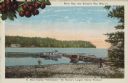
| Date: | 1915 |
|---|---|
| Description: | Caption reads: "Sister Bay, near Sturgeon Bay, Wis." and "In Door County 'Cherryland,' the Nation's Largest Cherry Producer." Sister Bay from a rocky beach... |

| Date: | 1915 |
|---|---|
| Description: | A composite plat map of the towns of Mequon, Saukville, Belgium, Fort Washington, and Fredonia. |
If you didn't find the material you searched for, our Library Reference Staff can help.
Call our reference desk at 608-264-6535 or email us at: