 Filter: Categories of Wisconsin Historical Images
Filter: FULL_DATE of 1915
Filter: Subject of maps
Filter: Categories of Wisconsin Historical Images
Filter: FULL_DATE of 1915
Filter: Subject of maps
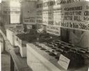
| Date: | 1915 |
|---|---|
| Description: | Exhibit at the Milwaukee County Fair devoted to Wisconsin's cranberry production. The exhibit includes cranberry plants, various cranberry varieties, cranb... |

| Date: | 1915 |
|---|---|
| Description: | This map shows roads, railroads, street railways, abandoned logging railroads, rural mail routes, telephone lines, schools, platted land, and state forest ... |

| Date: | 1915 |
|---|---|
| Description: | This map includes automobile routes through the state as well as routes in parts of Iowa, Michigan and Minnesota. Cities, counties, Lake Michigan, Lake Sup... |

| Date: | 1915 |
|---|---|
| Description: | This map displays various automobile routes through the state of Wisconsin and parts of Illinois, Iowa, Minnesota, and Michigan. Cities, counties, Lake Mic... |

| Date: | 1915 |
|---|---|
| Description: | This map shows highways in the state and includes in the left bottom margin information on the population to be served by proposed roads. There are handwri... |
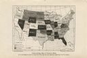
| Date: | 1915 |
|---|---|
| Description: | Map showing each state's work hour limitations for women. |
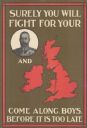
| Date: | 1915 |
|---|---|
| Description: | British poster with a circular framed portrait of the king dressed in a military uniform, and a red map of the United Kingdom. Text reads: "Surely You Will... |
If you didn't find the material you searched for, our Library Reference Staff can help.
Call our reference desk at 608-264-6535 or email us at: