 Filter: Categories of Wisconsin Historical Images
Filter: FULL_DATE of 1915
Filter: County of Sauk
Filter: Subject of water
Filter: Categories of Wisconsin Historical Images
Filter: FULL_DATE of 1915
Filter: County of Sauk
Filter: Subject of water
| Date: | 1915 |
|---|---|
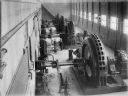
| Description: | Elevated view of a man standing near the generators inside the power house at the Prairie du Sac dam. The base of the generators is marked with the name of... |
| Date: | 1915 |
|---|---|
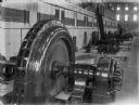
| Description: | A man is standing on a staircase overlooking an operating generator in the power house at the Prairie du Sac dam. |
| Date: | 1915 |
|---|---|
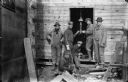
| Description: | Workers posing in a doorway at the Prairie du Sac dam construction site. Two men appear to be working on a gas lamp, while others are holding spools of wir... |
| Date: | 1915 |
|---|---|
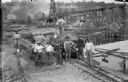
| Description: | Elevated view of a group of workers posing on the east bank of the Wisconsin River at the power dam construction site. One man is strumming his shovel like... |
| Date: | 1915 |
|---|---|
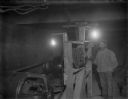
| Description: | A worker standing at the controls of a generator, most likely in the temporary power house at the Prairie du Sac dam site. The steam driven generator produ... |

| Date: | 1915 |
|---|---|
| Description: | A young woman sits on a log which lies over a stream bed in a wooded area. |
| Date: | 1915 |
|---|---|
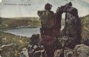
| Description: | Colorized postcard of the rock formation called the Devil's Doorway in Devil's Lake State Park. The lake, bluffs, trees and sky are visible in the backgrou... |

| Date: | 1915 |
|---|---|
| Description: | This 1915 map covers the section of the Wisconsin River in southern Adams, southeastern Juneau, northeastern Sauk, and northwestern Columbia counties. A po... |

| Date: | 1915 |
|---|---|
| Description: | Colorized postcard view of a bridge over a dam on a river. Trees are along both banks. Caption reads: "The High Bridge and Dam, Baraboo, Wis." |

| Date: | 1915 |
|---|---|
| Description: | A Sanborn fire insurance map of Sauk City created in 1915. |

| Date: | 1915 |
|---|---|
| Description: | A Sanborn fire insurance map of Sauk City created in 1915. |
If you didn't find the material you searched for, our Library Reference Staff can help.
Call our reference desk at 608-264-6535 or email us at: