 Filter: Categories of Wisconsin Historical Images
Filter: FULL_DATE of 1914
Filter: Subject of cities and towns
Filter: Categories of Wisconsin Historical Images
Filter: FULL_DATE of 1914
Filter: Subject of cities and towns

| Date: | 1914 |
|---|---|
| Description: | Elevated view of the wood yard and office. The stone structure on the right is the remnant of the National Furnace Company, an iron ore smelting company. C... |
| Date: | 1914 |
|---|---|
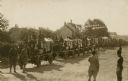
| Description: | Slightly elevated view of the United States Military surveying four wheel drive (FWD) trucks, manufactured in Clintonvlle, carrying supply boxes. Caption r... |

| Date: | 1914 |
|---|---|
| Description: | This map shows plat of the town, city limits, numbered blocks and lots, wards, local streets, roads, railroads, Capitol Square, Vilas Park, Edgewood Academ... |
| Date: | 1914 |
|---|---|
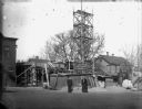
| Description: | After his success with the State Street and Pinckney Street car dealerships, Louis Schoelkopf built a new building at 210 E. Washington Avenue. The constru... |
| Date: | 1914 |
|---|---|
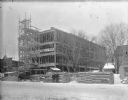
| Description: | View across street towards two men standing in front of the Schoelkopf dealership at 210 E. Washington Avenue as construction progresses on the three-story... |
| Date: | 1914 |
|---|---|
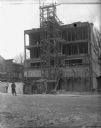
| Description: | View across street towards the construction at 210 E. Washington Avenue. There is scaffolding in front of the building, and Emma Schoelkopf is standing in ... |
| Date: | 1914 |
|---|---|
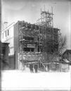
| Description: | Another view of the Schoelkopf construction site at 210 E. Washington Avenue. Two men stand in the street in front, one of whom may be Louis Schoelkopf. Th... |
| Date: | 1914 |
|---|---|
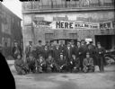
| Description: | View of group of men, and a young boy, gathered for a group portrait in front of the 210 E. Washington Avenue dealership. The Schoelkopf name has been adde... |

| Date: | 1914 |
|---|---|
| Description: | This map shows counties, roads, Lake Superior, Lake Michigan, and portions of surrounding states. Also included is a list of railroads showing miles and gr... |

| Date: | 1914 |
|---|---|
| Description: | This map shows main traveled routes. Portions of Lake Michigan, Lake Superior, Illinois, Iowa, Michigan and Minnesota are labeled. Also includes a legend s... |

| Date: | 1914 |
|---|---|
| Description: | This photostat map shows Fort Winnebago around 1931, land to be reserved for military purposes, roads to Fort Howard and Fort Crawford, "private property" ... |

| Date: | 1914 |
|---|---|
| Description: | This blueprint map includes manuscript annotations in red and shows number of acres and dates of acquisition (1905-1914) of each parcel of land, as well as... |

| Date: | 1914 |
|---|---|
| Description: | This map shows township grids, railroads, roads, and drainage. The area of the map covers northeastern Wisconsin and Menominee Indian reservation. Green Ba... |

| Date: | 1914 |
|---|---|
| Description: | Railroad workers posing in front of locomotive Engine No. 1224 at Stowell Station. From left to right are Fireman John F. Fohey, yardmaster John Rice, Waym... |

| Date: | 1914 |
|---|---|
| Description: | Hand-colored photomechanical view of a residential neighborhood with a large house on the corner. Trees line the street, and there is a windmill on the lef... |
| Date: | 1914 |
|---|---|
| Description: | View of the St. Rosa church and school located at the eastern side of the village on the south side of the road. Caption reads: "St. Rosa of Lima, C. & S. ... |

| Date: | 1914 |
|---|---|
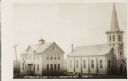
| Description: | View down road towards the wooden church with a steeple. This church is located on the west side of the city on the north side of the road. Caption reads: ... |

| Date: | 1914 |
|---|---|
| Description: | View down unpaved street towards an intersection in a residential neighborhood. Horses and buggies are down the road near houses. There is a church at the ... |
| Date: | 1914 |
|---|---|
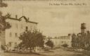
| Description: | View toward the mills with a water tower on the right. Caption reads: "The Badger Woolen Mills, Grafton, Wis." |

| Date: | 1914 |
|---|---|
| Description: | Color illustration of a hotel on a corner. Sign above entrance reads: "1882 Broadway Hotel 1912". Caption reads: "Broadway Hotel, Green Bay, Wis." |
If you didn't find the material you searched for, our Library Reference Staff can help.
Call our reference desk at 608-264-6535 or email us at: