 Filter: Categories of Wisconsin Historical Images
Filter: FULL_DATE of 1914
Filter: Subject of cities and towns
Filter: Categories of Wisconsin Historical Images
Filter: FULL_DATE of 1914
Filter: Subject of cities and towns

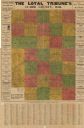
| Date: | 1914 |
|---|---|
| Description: | This early-20th century map of Clark County, Wisconsin, shows the township and range grid, sections, cities and villages, wagon roads, railroads, settlers,... |
| Date: | 1914 |
|---|---|
| Description: | This early-20th century map of Clark County, Wisconsin, shows the township and range grid, towns, sections, cities and villages, property owners and acreag... |

| Date: | 1914 |
|---|---|
| Description: | This 1914 map of Douglas County, Wisconsin, shows the township and range grid, towns, sections, cities and villages, roads, railroads, Indian trails, schoo... |

| Date: | 1914 |
|---|---|
| Description: | Map shows school houses, creameries, post offices, saw mills, grist mills, churches, cemeteries, town halls, stores, roads, state roads, and railroads. "Co... |

| Date: | 1914 |
|---|---|
| Description: | Shows land ownership by name, rural routes, improved roads, railroads, schools, churches, and cemeteries. "For list of small property owners, lift map at f... |
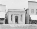
| Date: | 1914 |
|---|---|
| Description: | View from street of the facade of the Farmer's State Bank. The cornerstone of the building says "1913". A group of men sit on a bench in front of a store o... |

| Date: | 1914 |
|---|---|
| Description: | Shows lot numbers and dimensions; covers portion of the neighborhood currently known as Shorewood Hills. Includes red annotations showing houses and sold l... |
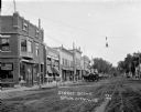
| Date: | 1914 |
|---|---|
| Description: | View down unpaved street towards the central business district. There is a drug store on the left decorated with flags, and the Farmers & Citizens Bank and... |
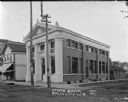
| Date: | 1914 |
|---|---|
| Description: | Corner view from unpaved street of the State Bank. A meat market is next door on the left. Flyers on the power poles are for an upcoming fair. A metal and ... |

| Date: | 1914 |
|---|---|
| Description: | Map shows townships, schools, saw mills, roads, railroads, and post offices. Text on the top left has a box of towns with land in Marathon County. Top righ... |

| Date: | 1914 |
|---|---|
| Description: | Three-quarter view of the front and side of Sorgs Creamery, a rectangular brick building with a collapsing awning. A wagon with and umbrella and barrels pu... |

| Date: | 1914 |
|---|---|
| Description: | View across road and railroad tracks towards the Wilton House Hotel. A portion of the back of a railroad car is on the right. Three men are sitting on the ... |

| Date: | 1914 |
|---|---|
| Description: | Map shows townships, schools, creameries, post offices, and roads. The left side of the map features a legend with symbols for points of interest. |
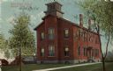
| Date: | 1914 |
|---|---|
| Description: | Exterior view of a school building. Caption reads: "First Ward School, Beaver Dam, Wis." |
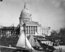
| Date: | 1914 |
|---|---|
| Description: | Elevated view of the Wisconsin State Capitol building, showing steel work of North Wing under construction. Crowds of people are gathered on the lawn for t... |

| Date: | 1914 |
|---|---|
| Description: | Photographic postcard of an exterior view from the street of a hospital with a large porch. Caption reads: "Yates Memorial Hospital, Berlin, Wis." |

| Date: | 1914 |
|---|---|
| Description: | Street view with frame residences in a small town. |

| Date: | 1914 |
|---|---|
| Description: | This map has relief shown by hachures and shows local streets, wards, districts, railroads, Fox River, and part of Bay of Green Bay. Wards are shown in dar... |

| Date: | 1914 |
|---|---|
| Description: | St. James Church, shown intact before being destroyed by fire May 9th, 1914. Black and white, with blue sky color added to top of card. Caption reads: "St.... |

| Date: | 1914 |
|---|---|
| Description: | View towards the front and right side of the St. James School. Caption reads: "St. James School, Destroyed by Fire May 9, 1914. Cooperstown, Wis." |
If you didn't find the material you searched for, our Library Reference Staff can help.
Call our reference desk at 608-264-6535 or email us at: