 Filter: Categories of Wisconsin Historical Images
Filter: FULL_DATE of 1914
Filter: Subject of cities and towns
Filter: Subject of education
Filter: Categories of Wisconsin Historical Images
Filter: FULL_DATE of 1914
Filter: Subject of cities and towns
Filter: Subject of education

| Date: | 1914 |
|---|---|
| Description: | Group portrait of the 1914 Sun Prairie freshman class. Included in the group is Bill Droster, grandfather of the donor of this image. |
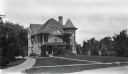
| Date: | 1914 |
|---|---|
| Description: | Exterior of building at 10 Babcock Drive. University of Wisconsin-Madison residence of Dean Harry Luman Russell (Dean of the College of Agriculture, 1907-... |
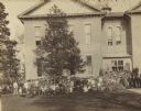
| Date: | 1914 |
|---|---|
| Description: | Large group of unidentified children and adults pose outside a large brick building. Some students are posing in open windows. |

| Date: | 1914 |
|---|---|
| Description: | View across street toward the front and right side of St. Mark's Parish School. A dirt lot is to the right. |
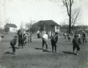
| Date: | 1914 |
|---|---|
| Description: | Children standing in a schoolyard playing baseball. Two buildings are in the far background. |

| Date: | 1914 |
|---|---|
| Description: | Plat book of Waukesha County. Pages 14 - 15. |

| Date: | 1914 |
|---|---|
| Description: | This map of Price County, Wisconsin, from the early 20th century shows land for sale by the Homemaker Land Company of Milwaukee. The township and range sys... |

| Date: | 1914 |
|---|---|
| Description: | This 1914 map of Price County, Wisconsin, shows land for sale by the Good Land Company and Dewitt van Ostrand of Phillips. Also shown are the township and ... |

| Date: | 1914 |
|---|---|
| Description: | This early-20th century map of Clark County, Wisconsin, shows the township and range grid, sections, cities and villages, wagon roads, railroads, settlers,... |

| Date: | 1914 |
|---|---|
| Description: | This 1914 map of Douglas County, Wisconsin, shows the township and range grid, towns, sections, cities and villages, roads, railroads, Indian trails, schoo... |

| Date: | 1914 |
|---|---|
| Description: | Shows land ownership by name, rural routes, improved roads, railroads, schools, churches, and cemeteries. "For list of small property owners, lift map at f... |

| Date: | 1914 |
|---|---|
| Description: | Map shows townships, schools, saw mills, roads, railroads, and post offices. Text on the top left has a box of towns with land in Marathon County. Top righ... |

| Date: | 1914 |
|---|---|
| Description: | Map shows townships, schools, creameries, post offices, and roads. The left side of the map features a legend with symbols for points of interest. |
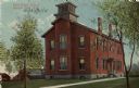
| Date: | 1914 |
|---|---|
| Description: | Exterior view of a school building. Caption reads: "First Ward School, Beaver Dam, Wis." |

| Date: | 1914 |
|---|---|
| Description: | View towards the front and right side of the St. James School. Caption reads: "St. James School, Destroyed by Fire May 9, 1914. Cooperstown, Wis." |

| Date: | 1914 |
|---|---|
| Description: | This map shows counties, roads, Lake Superior, Lake Michigan, and portions of surrounding states. Also included is a list of railroads showing miles and gr... |
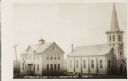
| Date: | 1914 |
|---|---|
| Description: | View of the St. Rosa church and school located at the eastern side of the village on the south side of the road. Caption reads: "St. Rosa of Lima, C. & S. ... |

| Date: | 1914 |
|---|---|
| Description: | Exterior view from street towards the school on a street corner. A bicycle is parked near the door. Caption reads: "New Ella Court School, Marinette, Wis." |

| Date: | 1914 |
|---|---|
| Description: | Pg. 44 West Half of Marion Township. Pg. 45 East Half of Marion Township. |
If you didn't find the material you searched for, our Library Reference Staff can help.
Call our reference desk at 608-264-6535 or email us at:
