Filter: Categories of Wisconsin Historical Images
Filter: FULL_DATE of 1913
Filter: Subject of rivers
Filter: Categories of Wisconsin Historical Images
Filter: FULL_DATE of 1913
Filter: Subject of rivers

| Date: | 1913 |
|---|---|
| Description: | Bird's-eye map of Superior. "The New Steel Center." |
| Date: | 1913 |
|---|---|
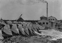
| Description: | Dam and hydroelectric power house, with a billowing smokestack and a crane in the background. |
| Date: | 1913 |
|---|---|
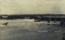
| Description: | View from below Little Falls Dam on the Chippewa River. |

| Date: | 1913 |
|---|---|
| Description: | Shows lands in green owned and for sale by Homeseekers Land Company, H.J. McKusick, Secretary. Map, part colored. No scale. Photographs on reverse of origi... |

| Date: | 1913 |
|---|---|
| Description: | Wisconsin map showing fifteen hundred miles of national highways proposed by the National Highways Association. Scale: 1:2,500,000. These highways will dir... |

| Date: | 1913 |
|---|---|
| Description: | A wall atlas of Sauk County, Wisconsin, displaying its 22 towns. On the left side are advertisements for local businesses. |
| Date: | 1913 |
|---|---|
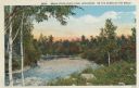
| Description: | Colorized postcard view of the Brule River flowing through the forest. Some trees show autumn color. Caption reads: "Brule River State Park, Wisconsin. Sce... |
| Date: | 1913 |
|---|---|
| Description: | Colorized postcard view of the Brule River flowing through the forest. Some trees show autumn color. Caption reads: "Brule River State Park, Wisconsin. On ... |
| Date: | 1913 |
|---|---|
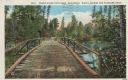
| Description: | Colorized postcard of a wooden bridge over the Brule River flowing through the forest. A person is on the far side of the bridge. Caption reads: "Brule Riv... |
| Date: | 1913 |
|---|---|
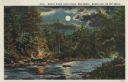
| Description: | Colorized postcard view of the Brule River flowing through the forest by moonlight. Some trees show autumn color. There is a campfire on the shore with thr... |
| Date: | 1913 |
|---|---|
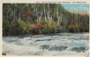
| Description: | Colorized postcard view of the Lower Falls on the Brule River flowing through the forest. Some trees are showing autumn color. Caption reads: "Brule River ... |
| Date: | 1913 |
|---|---|
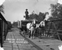
| Description: | A man drives a team of horses pulling a wagon across a bridge. The man is standing atop the barreled goods, holding the reins. There is dung on the road. |
| Date: | 1913 |
|---|---|
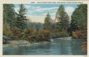
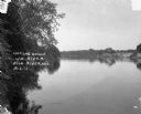
| Description: | A view across the river. Trees are along the left shoreline. |

| Date: | 1913 |
|---|---|
| Description: | A hand-colored map of Wisconsin and portions of eastern Iowa and Minnesota, northern Illinois, and the western part of Michigan’s Upper Peninsula, showing ... |

| Date: | 1913 |
|---|---|
| Description: | This 1913 map of Pepin County, Wisconsin, shows the township and range grid, towns, villages, rural routes, railroads, roads, schools, churches, cemeteries... |

| Date: | 1913 |
|---|---|
| Description: | This map shows city wards and government buildings. The map is oriented with north to upper right. |

| Date: | 1913 |
|---|---|
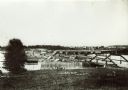
| Description: | A bird's eye view of the central business district. A river winding through the background. A building with a belfry in the foreground. |

| Date: | 1913 |
|---|---|
| Description: | Photographic postcard along shoreline of a group of people fishing at Rudolph Mill. Sherwin Gillett's wife's cousin, William Schmitt, is standing in the fo... |
If you didn't find the material you searched for, our Library Reference Staff can help.
Call our reference desk at 608-264-6535 or email us at: