 Filter: Categories of Wisconsin Historical Images
Filter: FULL_DATE of 1913
Filter: Subject of michigan, lake
Filter: Categories of Wisconsin Historical Images
Filter: FULL_DATE of 1913
Filter: Subject of michigan, lake

| Date: | 1913 |
|---|---|
| Description: | View of the canal. Caption reads: "The Canal, Stugeon[sic] Bay, Wis." |

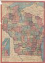
| Date: | 1913 |
|---|---|
| Description: | A hand-colored map of Wisconsin and portions of eastern Iowa and Minnesota, northern Illinois, and the western part of Michigan’s Upper Peninsula, showing ... |
| Date: | 1913 |
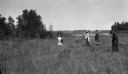
|---|---|
| Description: | A couple, center, and two girls pose in an opening on high ground. The girl on the left is the photographer's daughter, Margaret. The man carries two picn... |

| Date: | 1913 |
|---|---|
| Description: | Two of the photographer's children, Margaret (Sissy), left, and Ferdinand Leonard (Fedy), right, on Weborg Point. Fish Creek Harbor is in the background; t... |
| Date: | 1913 |
|---|---|
| Description: | This map shows automobile roads, cities, county boundaries, rivers, lakes, railroads, electric lines, and congressional districts. Included are portions of... |
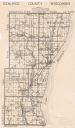
| Date: | 1913 |
|---|---|
| Description: | This map shows landownership, rural mail routes, rural buildings, railroads, U.S. national highways, state trunk highways, county trunk highways, township... |

| Date: | 1913 |
|---|---|
| Description: | This map details automobile routes throughout the state and parts of Illinois, Minnesota, Michigan, and Iowa. Cities, counties, Lake Michigan, Lake Superio... |

| Date: | 1913 |
|---|---|
| Description: | This map displays automobile routes across Wisconsin as well as Minnesota, Iowa, Michigan and Illinois. Cities, counties, Lake Michigan, Lake Superior, Gre... |
If you didn't find the material you searched for, our Library Reference Staff can help.
Call our reference desk at 608-264-6535 or email us at: