 Filter: Categories of Wisconsin Historical Images
Filter: FULL_DATE of 1913
Filter: Subject of maps
Filter: Categories of Wisconsin Historical Images
Filter: FULL_DATE of 1913
Filter: Subject of maps

| Date: | 1913 |
|---|---|
| Description: | Map showing the locations of IHC branch houses, works (factories), iron mines, coal lands, and timber lands. |
| Date: | 1913 |
|---|---|
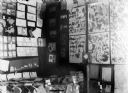
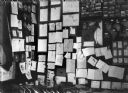
| Description: | Exhibit featuring pressed flowers, maps, drawings, and written compositions. |
| Date: | 1913 |
|---|---|
| Description: | Exhibit featuring maps, drawings, photographs, and compositions. |

| Date: | 1913 |
|---|---|
| Description: | This photocopy map shows plots with owners' names, land use both commercial and agricultural, and lot outlines on University land. Lake Mendota is labeled ... |

| Date: | 1913 |
|---|---|
| Description: | This map details automobile routes throughout the state and parts of Illinois, Minnesota, Michigan, and Iowa. Cities, counties, Lake Michigan, Lake Superio... |

| Date: | 1913 |
|---|---|
| Description: | This map displays automobile routes across Wisconsin as well as Minnesota, Iowa, Michigan and Illinois. Cities, counties, Lake Michigan, Lake Superior, Gre... |
If you didn't find the material you searched for, our Library Reference Staff can help.
Call our reference desk at 608-264-6535 or email us at: