 Filter: Categories of Wisconsin Historical Images
Filter: FULL_DATE of 1913
Filter: Subject of great lakes
Filter: Categories of Wisconsin Historical Images
Filter: FULL_DATE of 1913
Filter: Subject of great lakes

| Date: | 1913 |
|---|---|
| Description: | Bird's-eye map of Superior. "The New Steel Center." |

| Date: | 1913 |
|---|---|
| Description: | Wisconsin map showing fifteen hundred miles of national highways proposed by the National Highways Association. Scale: 1:2,500,000. These highways will dir... |
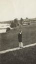
| Date: | 1913 |
|---|---|
| Description: | Jesse Stone walking on board sidewalk, with the Mission Inn along the shoreline in the background. |
If you didn't find the material you searched for, our Library Reference Staff can help.
Call our reference desk at 608-264-6535 or email us at: