 Filter: Categories of Wisconsin Historical Images
Filter: FULL_DATE of 1913
Filter: Subject of formations (geology)
Filter: Categories of Wisconsin Historical Images
Filter: FULL_DATE of 1913
Filter: Subject of formations (geology)
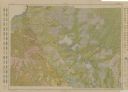
| Date: | 1913 |
|---|---|
| Description: | Shows soil types by colors and symbols. Relief shown by contours. Soils surveyed by W.J. Geib, Arthur E. Taylor and Guy Conrey. "Base map in part from U.S.... |

| Date: | 1913 |
|---|---|
| Description: | Elevated view of man seated on cliffs edge overlooking the dells of the Eau Claire River. Farther upstream is a bridge over the river. |

| Date: | 1913 |
|---|---|
| Description: | Elevated view of the Eau Claire River rushing over large rocky formations. A bridge crosses over the river on the left. Large tree trunks have been stacked... |

| Date: | 1913 |
|---|---|
| Description: | View up river towards a bridge over a rocky portion of the Eau Claire River. A women is standing on rocks beneath the bridge in the center, while a man sta... |

| Date: | 1913 |
|---|---|
| Description: | Text on front reads: "Devil's Anvil, Dells of the Wisconsin River." A rock formation and trees above the Wisconsin River. Devil's Anvil is also known as De... |
If you didn't find the material you searched for, our Library Reference Staff can help.
Call our reference desk at 608-264-6535 or email us at: