 Filter: Categories of Wisconsin Historical Images
Filter: FULL_DATE of 1912
Filter: Subject of superior, lake
Filter: Categories of Wisconsin Historical Images
Filter: FULL_DATE of 1912
Filter: Subject of superior, lake
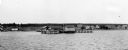
| Date: | 1912 |
|---|---|
| Description: | Elevated view of La Pointe dock taken from the water. |
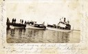
| Date: | 1912 |
|---|---|
| Description: | Boats and people at the Bayfield dock on Labor Day 1912. Boats include Thelma; Lusitania; which later became a U.S. Mail boat; Captain Angus'... |

| Date: | 1912 |
|---|---|
| Description: | This map shows parcel zones, counties, electric lines, and railroads. Includes text and charts about parcel post regulations and laws. Also includes an ins... |

| Date: | 1912 |
|---|---|
| Description: | This map from the U.S. General Land Office shows railroads, counties, cities and villages, rivers, lakes, U.S. Land Offices, Indian reservations, military ... |

| Date: | 1912 |
|---|---|
| Description: | This map is pen, ink, and pencil on tracing paper. The map was traced from U.S. Geological Survey map of Wisconsin, compiled in 1910-1911, and printed in 1... |
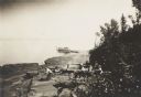
| Date: | 1912 |
|---|---|
| Description: | Picnic party on the rocks along the shore, among the Apostle Islands in Lake Superior. |

| Date: | 1912 |
|---|---|
| Description: | This map shows counties, roads, Lake Superior, Lake Michigan, and a portion of Illinois, Iowa, Minnesota, and Michigan. Also included is a list of railroad... |
If you didn't find the material you searched for, our Library Reference Staff can help.
Call our reference desk at 608-264-6535 or email us at: