 Filter: Categories of Wisconsin Historical Images
Filter: FULL_DATE of 1912
Filter: Subject of streams
Filter: Categories of Wisconsin Historical Images
Filter: FULL_DATE of 1912
Filter: Subject of streams
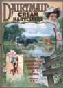
| Date: | 1912 |
|---|---|
| Description: | Advertising poster for the Dairymaid cream harvester (cream separator). Features color illustrations of grazing cows near a stream, a woman with a pail ov... |
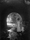
| Date: | 1912 |
|---|---|
| Description: | Hattie Taylor and daughter Tannisse walk under a Milwaukee park culvert. |
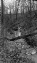
| Date: | 1912 |
|---|---|
| Description: | A woman and small girl balance on a log crossing a small stream in a ravine. The trees and bushes are bare. |

| Date: | 1912 |
|---|---|
| Description: | This map shows the area around Fort McCoy, labeled "U.S. Military Reservation," and Camp Douglas in the Sparta-Tomah region. Road, railroads, towns, cities... |

| Date: | 1912 |
|---|---|
| Description: | A map of Monroe County, Wisconsin showing townships, the towns of Sparta, Tomah, Oakdale, Wilton, Cashton, Glendale, Kendall and Wyeville, as well as the U... |
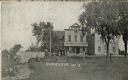
| Date: | 1912 |
|---|---|
| Description: | View along stream towards people standing in front of buildings and near a stone bridge. The buildings include a post office and a feed mill. Caption reads... |

| Date: | 1912 |
|---|---|
| Description: | View of a stream going through a park. Caption reads: "Picnic Grounds, Silver Creek, Manitowoc, Wis." |

| Date: | 1912 |
|---|---|
| Description: | Text on front reads: "The Old Swimming Hole, Whitewater, Wis." A swimming area in a river, with a bridge in the background, surrounded by trees. |

| Date: | 1912 |
|---|---|
| Description: | Text on front reads: "The Old Swimming Hole, Whitewater, Wis." |

| Date: | 1912 |
|---|---|
| Description: | A plat map of the township of Casco. Created by Geo. A. Ogle. |
If you didn't find the material you searched for, our Library Reference Staff can help.
Call our reference desk at 608-264-6535 or email us at:
