Filter: Categories of Wisconsin Historical Images
Filter: FULL_DATE of 1912
Filter: Subject of rivers
Filter: Categories of Wisconsin Historical Images
Filter: FULL_DATE of 1912
Filter: Subject of rivers
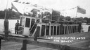
| Date: | 1912 |
|---|---|
| Description: | Suffragists sitting aboard the Mary E. at dockside on the Wolf River. The boat sports a banner reading: "Votes for Women." |
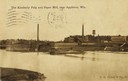
| Date: | 1912 |
|---|---|
| Description: | View from shoreline toward the mill on the opposite shoreline. Caption reads: "Kimberly Pulp and Paper Mill, near Appleton, Wis." |
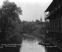
| Date: | 1912 |
|---|---|
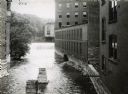
| Description: | View looking down the Crawfish River, with a large building with a three-story balcony on the right. A man and a boy are in a boat docked at the steps to t... |
| Date: | 1912 |
|---|---|
| Description: | Elevated view of the dam and power plant on the Red Cedar River. Caption reads: "Menominie, Wis. Bird's Eye View, Water Power and Plants." |
| Date: | 1912 |
|---|---|
| Description: | Water pouring over a dam near International Harvester's Osborne Works. The factory was later known as "Auburn Works." |

| Date: | 1912 |
|---|---|
| Description: | Sanborn insurance map of the main street in Potosi, Wisconsin, with an inset for the Potosi Brewery. |

| Date: | 1912 |
|---|---|
| Description: | A bridge with both a wooden walkway for pedestrians and a dirt road for automobiles. Two men and a horse are standing on the other side of the bridge. |
| Date: | 1912 |
|---|---|
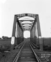
| Description: | View across a railroad bridge with metal truss system over the Sugar River. |
| Date: | 1912 |
|---|---|
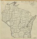
| Description: | An ink and pencil on paper map of Wisconsin that shows contemporary county divisions in the state. The map depicts the locations of some of the rivers that... |

| Date: | 1912 |
|---|---|
| Description: | This map from the U.S. General Land Office shows railroads, counties, cities and villages, rivers, lakes, U.S. Land Offices, Indian reservations, military ... |

| Date: | 1912 |
|---|---|
| Description: | This map is pen, ink, and pencil on tracing paper. The map was traced from U.S. Geological Survey map of Wisconsin, compiled in 1910-1911, and printed in 1... |
| Date: | 1912 |
|---|---|
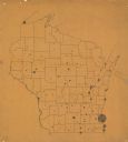
| Description: | This map is pen and ink on paper. The map was traced from a more detailed population dot map, this map shows only the major towns and cities in southern Wi... |
| Date: | 1912 |
|---|---|
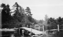
| Description: | A footbridge crossing Fish Creek into Peninsula Stat Park. |

| Date: | 1912 |
|---|---|
| Description: | Elevated view of a construction site of a bridge across the cutoff on the river. |

| Date: | 1912 |
|---|---|
| Description: | This outline map of Sauk County, Wisconsin, shows the towns, cities and villages, railroads, and streams in the county. |

| Date: | 1912 |
|---|---|
| Description: | This early 20th century map of Barron County, Wisconsin, shows the township and range grid, towns, sections, cities and villages, railroads, roads, houses,... |

| Date: | 1912 |
|---|---|
| Description: | Shows wards, sections, plat additions, selected buildings, churches, schools, and manufacturing companies. "We have revised this map from H. McCallum’s 189... |

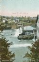
| Date: | 1912 |
|---|---|
| Description: | Elevated view of the river with trees on the left. On the right, two young boys are fishing from a rowboat in the river near a landing at the back of a thr... |
If you didn't find the material you searched for, our Library Reference Staff can help.
Call our reference desk at 608-264-6535 or email us at: