 Filter: Categories of Wisconsin Historical Images
Filter: FULL_DATE of 1912
Filter: Subject of michigan, lake
Filter: Categories of Wisconsin Historical Images
Filter: FULL_DATE of 1912
Filter: Subject of michigan, lake
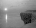
| Date: | 1912 |
|---|---|
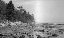
| Description: | Sunrise over a frozen cliff on Lake Michigan. |

| Date: | 1912 |
|---|---|
| Description: | Large crowd of passengers on the whaleback excursion steamer "Christopher Columbus". |

| Date: | 1912 |
|---|---|
| Description: | Three women and a child are wading at the Lake Park shoreline. The women are identified as Hattie Taylor and friends, and the child as Tannisse Taylor. |

| Date: | 1912 |
|---|---|
| Description: | This map shows parcel zones, counties, electric lines, and railroads. Includes text and charts about parcel post regulations and laws. Also includes an ins... |

| Date: | 1912 |
|---|---|
| Description: | This map from the U.S. General Land Office shows railroads, counties, cities and villages, rivers, lakes, U.S. Land Offices, Indian reservations, military ... |

| Date: | 1912 |
|---|---|
| Description: | This map is pen, ink, and pencil on tracing paper. The map was traced from U.S. Geological Survey map of Wisconsin, compiled in 1910-1911, and printed in 1... |

| Date: | 1912 |
|---|---|
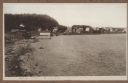
| Description: | View down dirt road leading to the Carlson farm at Nelson Bay in Peninsula State Park. A man stands in the background among the farm buildings near a parke... |
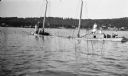
| Date: | 1912 |
|---|---|
| Description: | The photographer's daughters, from left, Helen, Alice, Margaret and son Ferdinand Leonard at the wheel, pose on a two-masted boat, the Martha G., wh... |
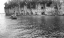
| Date: | 1912 |
|---|---|
| Description: | A launch with men standing on the deck passes close to rocky bluffs as seagulls fly overhead. |
| Date: | 1912 |
|---|---|
| Description: | The Cana Island lighthouse and keeper's house with the rocky shore in the foreground. |
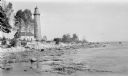
| Date: | 1912 |
|---|---|
| Description: | Cana Island lighthouse is seen in the far distance across the stony shoreline along Lake Michigan. |
| Date: | 1912 |
|---|---|
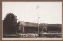
| Description: | View from water of simple frame structure with rustic porch rail standing on the Fish Creek beach. A pier extends from the porch and a flag flies on a tall... |
| Date: | 1912 |
|---|---|
| Description: | View looking west from the Hotz property on Fish Creek Beach. The Thorp bathhouse is on the left, with the Welcker bathhouses beyond. There are houses an... |

| Date: | 1912 |
|---|---|
| Description: | This map shows ward numbers, streets, railroads, electric car lines, parks, steam railways, section numbers, Lake Michigan and one mile concentric circles ... |

| Date: | 1912 |
|---|---|
| Description: | This map shows counties, roads, Lake Superior, Lake Michigan, and a portion of Illinois, Iowa, Minnesota, and Michigan. Also included is a list of railroad... |
| Date: | 1912 |
|---|---|
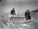
| Description: | Hattie Taylor and her neighbors on the icy shoreline of Lake Michigan near the row boat "Kate E. Howard." |

| Date: | 1912 |
|---|---|
| Description: | A plat map of the township of West Kewaunee. |
If you didn't find the material you searched for, our Library Reference Staff can help.
Call our reference desk at 608-264-6535 or email us at:
