Filter: Categories of Wisconsin Historical Images
Filter: FULL_DATE of 1912
Filter: Subject of lakes
Filter: Categories of Wisconsin Historical Images
Filter: FULL_DATE of 1912
Filter: Subject of lakes
| Date: | 1912 |
|---|---|
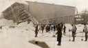
| Description: | Men harvesting ice at the Conklin Ice House on Lake Mendota. The men are using pike poles to slide the blocks to the conveyor and U-shaped tools to split p... |
| Date: | 1912 |
|---|---|
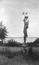
| Description: | Dr. E.A. Birge in his element, reading an anemometer of the weather data station on Green Lake. |

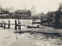
| Date: | 1912 |
|---|---|
| Description: | Elevated view over town towards the lake. Signs on some of the buildings read: "Old Partner Tobacco"; "Wisconsin Bag & Burlap Co."; "M. Burstein [?] and As... |
| Date: | 1912 |
|---|---|
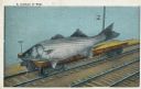
| Description: | Photomontage of a giant fish resting on a single flatbed railroad car, next to a lake. Black text above the image field reads, "A Carload of Fish." |
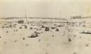
| Date: | 1912 |
|---|---|
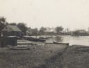
| Description: | A fishing settlement. Small buildings and boats line a bay, with sand and a piece of driftwood in the foreground. |
| Date: | 1912 |
|---|---|
| Description: | A fishing settlement. Two piers at the shoreline with a sandy beach, one with a ramp next to it. There are several buildings in the background. Two tugbo... |

| Date: | 1912 |
|---|---|
| Description: | Church and school seen from Kosciuszko Park. Located across a lake, behind some trees and bushes. A woman is sitting on some decorative stones next to the ... |
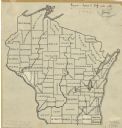
| Date: | 1912 |
|---|---|
| Description: | An ink and pencil on paper map of Wisconsin that shows contemporary county divisions in the state. The map depicts the locations of some of the rivers that... |

| Date: | 1912 |
|---|---|
| Description: | This map from the U.S. General Land Office shows railroads, counties, cities and villages, rivers, lakes, U.S. Land Offices, Indian reservations, military ... |

| Date: | 1912 |
|---|---|
| Description: | This map is pen, ink, and pencil on tracing paper. The map was traced from U.S. Geological Survey map of Wisconsin, compiled in 1910-1911, and printed in 1... |

| Date: | 1912 |
|---|---|
| Description: | This early 20th century map of Barron County, Wisconsin, shows the township and range grid, towns, sections, cities and villages, railroads, roads, houses,... |
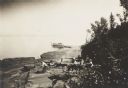
| Date: | 1912 |
|---|---|
| Description: | Picnic party on the rocks along the shore, among the Apostle Islands in Lake Superior. |
| Date: | 1912 |
|---|---|
| Description: | This view is looking northeast from the site of Norway Springs at the north end of Trout Lake in the spring. In the foreground are tree stumps; in the back... |

| Date: | 1912 |
|---|---|
| Description: | View across water of the east shore of Trout Lake. Caption reads: "East Shore. Trout Lake, Vilas Co. Wis." |

| Date: | 1912 |
|---|---|
| Description: | This blueprint manuscript map shows landownership, mills, railroad, churches, public buildings, the old cemetery, and the Chippewa River and Reservoir. The... |

| Date: | 1912 |
|---|---|
| Description: | This manuscript blueprint map shows numbered buildings and manuscript annotations. Lake Mendota and streets are labeled. |

| Date: | 1912 |
|---|---|
| Description: | Marinette County, Township 36 N., Range 19 E. |

| Date: | 1912 |
|---|---|
| Description: | Marinette County, Township 36 N., Range 20 E. |

| Date: | 1912 |
|---|---|
| Description: | Marinette County, Fract. Township 37 N., Ranges 21 and 22 E. |
If you didn't find the material you searched for, our Library Reference Staff can help.
Call our reference desk at 608-264-6535 or email us at: