 Filter: Categories of Wisconsin Historical Images
Filter: FULL_DATE of 1912
Filter: Subject of human settlements
Filter: Categories of Wisconsin Historical Images
Filter: FULL_DATE of 1912
Filter: Subject of human settlements

| Date: | 1912 |
|---|---|
| Description: | A map of Monroe County, Wisconsin showing townships, the towns of Sparta, Tomah, Oakdale, Wilton, Cashton, Glendale, Kendall and Wyeville, as well as the U... |

| Date: | 1912 |
|---|---|
| Description: | This outline map of Sauk County, Wisconsin, shows the towns, cities and villages, railroads, and streams in the county. |

| Date: | 1912 |
|---|---|
| Description: | This early 20th century map of Barron County, Wisconsin, shows the township and range grid, towns, sections, cities and villages, railroads, roads, houses,... |
| Date: | 1912 |
|---|---|
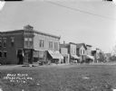
| Description: | View across road of the central business section. The commerical buildings along the sidewalk include a printer, butcher, barber and jeweler. Above the sho... |

| Date: | 1912 |
|---|---|
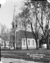
| Description: | View from across street of the wooden Presbyterian Church with steeple. The round, stained glass windows on the steeple and the front of the church have a ... |

| Date: | 1912 |
|---|---|
| Description: | View from drive of the High School and grounds. The building has a gable roof and iron fence detailing around the edge. On the right side of the building i... |
| Date: | 1912 |
|---|---|
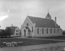
| Description: | Exterior view of Catholic Church, including parsonage and grounds. |
| Date: | 1912 |
|---|---|
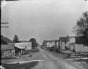
| Description: | View looking down unpaved Main Street, with wagons and carts parked near the curb on the left near a building with a sign for a "Garage." Pedestrians are a... |

| Date: | 1912 |
|---|---|
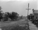
| Description: | View down unpaved Main Street. There is a T-intersection on the right. On the left are a row of storefronts with a dog and pedestrians on the sidewalk. Bus... |
| Date: | 1912 |
|---|---|
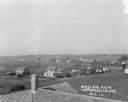
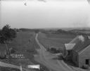
| Description: | Elevated view of town with farm fields in the foreground, and low, rolling hills in the background. There is a church steeple in the far background on the ... |
| Date: | 1912 |
|---|---|
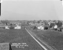
| Description: | Elevated view over rooftops. Farm fields and houses are in the background. |
| Date: | 1912 |
|---|---|
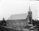
| Description: | Exterior view of the Norwegian Lutheran Church with steeple. The church has arched stained glass windows in the front and on the sides, and is surrounded b... |
| Date: | 1912 |
|---|---|
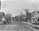
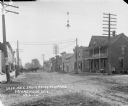
| Description: | Street scene looking east from the corner of the Reeder's Hotel. Men stand near horses and wagons on the left near a sidewalk and storefronts. A small dog ... |
| Date: | 1912 |
|---|---|
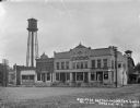
| Description: | View across lawn of a commercial block, including the Farmers Merchants Bank, general store, and meat market. Horses and wagons, and an automobile are park... |
| Date: | 1912 |
|---|---|
| Description: | View down Main Street. On the left is a barn covered with circus broadsides. Across the street is a building with a storefront and awning, and a sign that ... |

| Date: | 1912 |
|---|---|
| Description: | View from street towards a row of brick buildings. On the left corner is a building with a sign on the roof that says "W. Welsh." The entrance has a balcon... |
| Date: | 1912 |
|---|---|
| Description: | View from hill of the left side of St. Phillips Church, a large brick building with twelve arched stained glass windows, as well as twelve windows along th... |

| Date: | 1912 |
|---|---|
| Description: | Shows wards, sections, plat additions, selected buildings, churches, schools, and manufacturing companies. "We have revised this map from H. McCallum’s 189... |
| Date: | 1912 |
|---|---|
| Description: | View down unpaved street with a school building on the left on the opposite side of the street. A board sidewalk leads to a two-story dwelling on the right... |
| Date: | 1912 |
|---|---|
| Description: | A scenic view over rolling hills with a road leading to the horizon. There are trees, fields and farm buildings on the left. In the foreground on the right... |
If you didn't find the material you searched for, our Library Reference Staff can help.
Call our reference desk at 608-264-6535 or email us at: