 Filter: Categories of Wisconsin Historical Images
Filter: FULL_DATE of 1912
Filter: Subject of hotels
Filter: Categories of Wisconsin Historical Images
Filter: FULL_DATE of 1912
Filter: Subject of hotels

| Date: | 1912 |
|---|---|
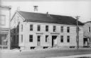
| Description: | View from road of the Briggs Hotel, which burned down in 1913. |
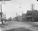
| Date: | 1912 |
|---|---|
| Description: | View from across road of Baxter House, a two-story wooden structure. A man is sitting on the roof working on the chimney. A bell tower is seen behind the r... |
| Date: | 1912 |
|---|---|
| Description: | Elevated view looking east on Grand Avenue from the corner of Grand Avenue and 2nd Street. Plankinton Block was located between West Water (now Plankinton ... |

| Date: | 1912 |
|---|---|
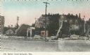
| Description: | City Hall Square. A statue in a circular area is in the center of the road. Horses and carriages are in the street in front of the hotel. Three flags are o... |
| Date: | 1912 |
|---|---|
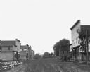
| Description: | View down Main Street. A team of horses pulling a buggy is parked at the curb near a storefront on the right. There is a shoe store and hotel on the left. |

| Date: | 1912 |
|---|---|
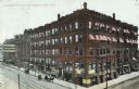
| Description: | View across street of the bank and hotel building along a commercial street. |
| Date: | 1912 |
|---|---|
| Description: | Colorized postcard of "The Ruins." A brick hotel (possibly the MLAKAR HOTEL) is behind and to the right of the old foundation. Various signs are pasted on ... |
| Date: | 1912 |
|---|---|
| Description: | Street scene looking east from the corner of the Reeder's Hotel. Men stand near horses and wagons on the left near a sidewalk and storefronts. A small dog ... |

| Date: | 1912 |
|---|---|
| Description: | View from street towards a row of brick buildings. On the left corner is a building with a sign on the roof that says "W. Welsh." The entrance has a balcon... |

| Date: | 1912 |
|---|---|
| Description: | Colorized view across street towards pedestrians and horse-drawn vehicles in front of a row of shops. Caption reads: "Busy Scene on Main Street, Bangor, Wi... |
If you didn't find the material you searched for, our Library Reference Staff can help.
Call our reference desk at 608-264-6535 or email us at:


