 Filter: Categories of Wisconsin Historical Images
Filter: FULL_DATE of 1912
Filter: Subject of cities and towns
Filter: Categories of Wisconsin Historical Images
Filter: FULL_DATE of 1912
Filter: Subject of cities and towns

| Date: | 1912 |
|---|---|
| Description: | View upriver towards the dam in front, with the town of Black River Falls in the background on a hilly shoreline. There is a railroad bridge over the river... |

| Date: | 1912 |
|---|---|
| Description: | Outdoor view of a group of people on the rock in front of the dam located in front of Black River Falls, with several structures in the background. The gat... |

| Date: | 1912 |
|---|---|
| Description: | Black and white photographic postcard view of the Grand Avenue bridge across the Chippewa river, looking through the trusses along the streetcar tracks. Ca... |

| Date: | 1912 |
|---|---|
| Description: | This map shows ward numbers, streets, railroads, electric car lines, parks, steam railways, section numbers, Lake Michigan and one mile concentric circles ... |

| Date: | 1912 |
|---|---|
| Description: | This map shows counties, roads, Lake Superior, Lake Michigan, and a portion of Illinois, Iowa, Minnesota, and Michigan. Also included is a list of railroad... |

| Date: | 1912 |
|---|---|
| Description: | View across snow-covered street towards a group of men and one boy standing in front of the Jackson County Bank, located at the southwest corner of Main an... |

| Date: | 1912 |
|---|---|
| Description: | Maud McCreery speaking from the back seat of a car during a Women's Suffrage in Wisconsin Campaign. Mrs. McCreery was a women's suffrage activist who worke... |
| Date: | 1912 |
|---|---|
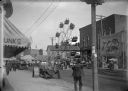
| Description: | View from sidewalk of a street carnival with tents, circus banners and a Ferris Wheel set up in the middle of the street. Signboards advertise ice cream an... |
| Date: | 1912 |
|---|---|
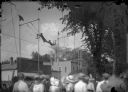
| Description: | View from crowd of a pair of trapeze acrobats performing at a street fair. |

| Date: | 1912 |
|---|---|
| Description: | This map shows a school reserve, swamp land, railroads, and selected buildings. |

| Date: | 1912 |
|---|---|
| Description: | This blueprint manuscript map shows landownership, mills, railroad, churches, public buildings, the old cemetery, and the Chippewa River and Reservoir. The... |

| Date: | 1912 |
|---|---|
| Description: | This blueprint manuscript map shows selected buildings, roads, and the Peshtigo River. |

| Date: | 1912 |
|---|---|
| Description: | This manuscript blueprint map shows numbered buildings and manuscript annotations. Lake Mendota and streets are labeled. |

| Date: | 1912 |
|---|---|
| Description: | This manuscript blueprint map shows land conditions for future construction development on the University of Wisconsin-Madison campus. It highlights roads ... |

| Date: | 1912 |
|---|---|
| Description: | Marinette County, Township 36 N., Range 19 E. |

| Date: | 1912 |
|---|---|
| Description: | Marinette plat map, Township 37 N., Range 19 E. |

| Date: | 1912 |
|---|---|
| Description: | Marinette County, Township 36 N., Range 20 E. |

| Date: | 1912 |
|---|---|
| Description: | Marinette County, Township 37 N., Range 20 E. |

| Date: | 1912 |
|---|---|
| Description: | Marinette County, Fract. Township 36 N., Ranges 21 and 22 E. |

| Date: | 1912 |
|---|---|
| Description: | Marinette County, Fract. Township 37 N., Ranges 21 and 22 E. |
If you didn't find the material you searched for, our Library Reference Staff can help.
Call our reference desk at 608-264-6535 or email us at: