 Filter: Categories of Wisconsin Historical Images
Filter: FULL_DATE of 1912
Filter: County of Monroe
Filter: Categories of Wisconsin Historical Images
Filter: FULL_DATE of 1912
Filter: County of Monroe
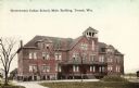
| Date: | 1912 |
|---|---|
| Description: | Exterior view of the main building. Caption reads: "Government Indian School, Main Building, Tomah, Wis." |

| Date: | 1912 |
|---|---|
| Description: | This map shows the area around Fort McCoy, labeled "U.S. Military Reservation," and Camp Douglas in the Sparta-Tomah region. Road, railroads, towns, cities... |

| Date: | 1912 |
|---|---|
| Description: | A map of Monroe County, Wisconsin showing townships, the towns of Sparta, Tomah, Oakdale, Wilton, Cashton, Glendale, Kendall and Wyeville, as well as the U... |
If you didn't find the material you searched for, our Library Reference Staff can help.
Call our reference desk at 608-264-6535 or email us at: