 Filter: Categories of Wisconsin Historical Images
Filter: FULL_DATE of 1912
Filter: County of Marinette
Filter: Categories of Wisconsin Historical Images
Filter: FULL_DATE of 1912
Filter: County of Marinette
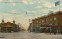
| Date: | 1912 |
|---|---|
| Description: | View of the square, with storefronts surrounding it. There is a pavilion on the far side. Caption reads: "Dunlap Square, Marinette, Wis." |
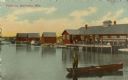
| Date: | 1912 |
|---|---|
| Description: | View across water toward buildings on the right, with men standing on a platform at the shoreline in front of a large building. Three more smaller building... |

| Date: | 1912 |
|---|---|
| Description: | Exterior view of the Post Office. Caption reads: "U.S. Post Office, Marinette, Wis." |

| Date: | 1912 |
|---|---|
| Description: | Shows wards, sections, plat additions, selected buildings, churches, schools, and manufacturing companies. "We have revised this map from H. McCallum’s 189... |

| Date: | 1912 |
|---|---|
| Description: | This blueprint manuscript map shows selected buildings, roads, and the Peshtigo River. |

| Date: | 1912 |
|---|---|
| Description: | Marinette County, Township 37 N., Range 20 E. |

| Date: | 1912 |
|---|---|
| Description: | A portion of a plat map of Marinette County showing township 30 N., range 21 E., and part of township 29 N., range 21 E. |

| Date: | 1912 |
|---|---|
| Description: | View looking across to the left at a city block of storefronts, and a church in the distance. A man is standing in the street in the right foreground. Capt... |
If you didn't find the material you searched for, our Library Reference Staff can help.
Call our reference desk at 608-264-6535 or email us at: