 Filter: Categories of Wisconsin Historical Images
Filter: FULL_DATE of 1911
Filter: Subject of transportation
Filter: Categories of Wisconsin Historical Images
Filter: FULL_DATE of 1911
Filter: Subject of transportation

| Date: | 1911 |
|---|---|
| Description: | View towards a construction site, with men working near a railway track with sand haulers. Location identified as the fill and reconstruction of Town Creek... |

| Date: | 1911 |
|---|---|
| Description: | View towards a steam shovel working on a hill by a railway and water tank. Location identified as the cutting down of German Hill for fill to reconstruct t... |
| Date: | 1911 |
|---|---|
| Description: | View towards men standing among several large rocks, and a road made with logs. Identified as the lying of logs on the sand bar after the flood of Black Ri... |

| Date: | 1911 |
|---|---|
| Description: | View down wall towards a construction site. On the right arec men by a railway track with sand haulers, and a brick viaduct. Location identified as the f... |

| Date: | 1911 |
|---|---|
| Description: | View towards a man standing on a sled behind a team of two horses on a snow-covered city street in front of a two-story brick building. Location identified... |

| Date: | 1911 |
|---|---|
| Description: | View towards a construction site, with men working by a railway track with sand haulers, and a brick viaduct. Location identified as the fill and reconstru... |

| Date: | 1911 |
|---|---|
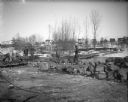
| Description: | View towards a construction site, with wreckage, and men working on the wreckage. Location identified as the fill and reconstruction of Town Creek after th... |

| Date: | 1911 |
|---|---|
| Description: | View towards several men on wreckage below several buildings. Identified as the damage after the flood in Black River Falls in October 1911, and showing th... |

| Date: | 1911 |
|---|---|
| Description: | View towards several men on wreckage below several buildings. Identified as the damage after the flood in Black River Falls in October 1911 and showing the... |

| Date: | 1911 |
|---|---|
| Description: | Elevated view of a construction site, with wreckage behind a wooden wall. Location identified as the fill and reconstruction of Town Creek after the 1911 f... |

| Date: | 1911 |
|---|---|
| Description: | View of a construction site with wreckage in a ditch. Location identified as the fill and reconstruction of Town Creek after the 1911 flood in Black River ... |
| Date: | 1911 |
|---|---|
| Description: | Photographic postcard of James Street, looking east, with pedestrians and horse-drawn vehicles. Caption reads: "James St. Columbus Wis." |

| Date: | 1911 |
|---|---|
| Description: | View of an overturned delivery wagon near M. Krachmer's camp, five miles north of Antigo. Caption reads: "A Bad Spill By M. Krachner's." |
| Date: | 1911 |
|---|---|
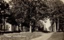
| Description: | View along dirt path in a park. There is a soldier's monument in the background just beyond trees, and a brick building on the left. |
| Date: | 1911 |
|---|---|
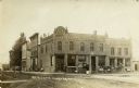
| Description: | View from unpaved street towards the Alb. R. Schwahn building on a corner. There are pedestrians on the sidewalk, and horse-drawn vehicles are parked near ... |
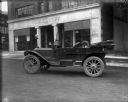
| Date: | 1911 |
|---|---|
| Description: | A Maxwell GA touring car is parked in the street in front of the Schoelkopf dealership at 210 East Washington Avenue. |

| Date: | 1911 |
|---|---|
| Description: | This map shows ward numbers, streets, railroads, electric car lines, parks, steam railways, section numbers, Lake Michigan and one mile concentric circles ... |

| Date: | 1911 |
|---|---|
| Description: | This map shows city wards, block numbers, parks, cemeteries, roads, railroads, Lake Michigan, and selected buildings. Also included are indexes "Milwaukee ... |

| Date: | 1911 |
|---|---|
| Description: | This map shows plat of town, local streets, numbered lots, blocks, and wards, roads, Lake Menomin, Wilson Creek, Red Cedar River, and land ownership by nam... |

| Date: | 1911 |
|---|---|
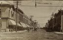
| Description: | View across Main Street, between First and Water Streets. Businesses include A.H. Hagen & Son on the left, and C.E. Mower on the right. A lamppost is in th... |
If you didn't find the material you searched for, our Library Reference Staff can help.
Call our reference desk at 608-264-6535 or email us at: