 Filter: Categories of Wisconsin Historical Images
Filter: FULL_DATE of 1911
Filter: Subject of school buildings
Filter: Categories of Wisconsin Historical Images
Filter: FULL_DATE of 1911
Filter: Subject of school buildings
| Date: | 1911 |
|---|---|
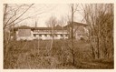
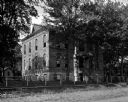
| Description: | Southern elevation of Hillside Home School, designed by Frank Lloyd Wright for his aunts, Jane and Ellen Lloyd Jones. Taliesin is located in the vicinity o... |
| Date: | 1911 |
|---|---|
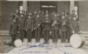
| Description: | Group portrait of the Tomah Indian School Band in uniform, holding their instruments. |
| Date: | 1911 |
|---|---|
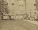
| Description: | Large group of children and adults posed on the lawn outside a large brick building. Some students are posing in open windows. |
| Date: | 1911 |
|---|---|
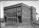
| Description: | Exterior view of the brick Blue River Township and Grade School under construction. The cost of building was $7,000. |

| Date: | 1911 |
|---|---|
| Description: | Delos and Marian Dudley riding cart on sidewalk at 1909 Regent Street. Randall School is probably the large building in the background. |
| Date: | 1911 |
|---|---|
| Description: | View across unpaved road towards an unidentified high school. A simple fence lines the sidewalk in front of the school. |
| Date: | 1911 |
|---|---|
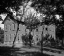
| Description: | Exterior view of a brick school building with an ornate tower. |
| Date: | 1911 |
|---|---|
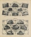
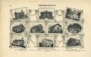
| Description: | A decorative page with photographs of school buildings in the township of Verona and Vienna. Some of the photographs have groups of students with their tea... |

| Date: | 1911 |
|---|---|
| Description: | View of the remodeled high school with a group of students outside. |

| Date: | 1911 |
|---|---|
| Description: | This 1911 map from the U.S. Post Office Dept. shows rural delivery routes, active and discontinued post offices, selected rural landowners and houses, chur... |

| Date: | 1911 |
|---|---|
| Description: | This 1911 map from the U.S. Post Office Dept. shows rural delivery routes, active and discontinued post offices, collection boxes, selected rural landowner... |

| Date: | 1911 |
|---|---|
| Description: | Blue line print. Shows post offices, houses, schools, churches, roads, routes, rivers, and railroads. Includes explanation of symbols. "H.G.M. October 12,... |
| Date: | 1911 |
|---|---|
| Description: | Shows routes, post offices, churches, houses, schools, roads, and collection boxes. "B. Oct. 11, 1911." Blue line print. "Sheboygan Co., Wis. 587." |

| Date: | 1911 |
|---|---|
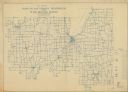
| Description: | This 1911 map from the U.S. Post Office Department shows rural delivery routes, active and discontinued post offices, selected rural landowners and houses,... |
| Date: | 1911 |
|---|---|
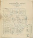
| Description: | "Standard Historical Atlas of Dane County, Wisconsin." Top half of page 98, showing all of the different district schools in Middleton. |
| Date: | 1911 |
|---|---|
| Description: | Shows roads, railroads, post offices, schools, houses, churches, routes, and collection boxes. Includes distant chart and explanation. "Price 35 cents"--... |

| Date: | 1911 |
|---|---|
| Description: | Shows roads, railroads, post offices, schools, houses, churches, and routes. Includes distant chart and explanation. "Price 35 cents"--Upper left margin. "... |
| Date: | 1911 |
|---|---|
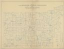
| Description: | Map shows routes, post offices, houses, churches, schools, and roads of La Fayette County rural delivery service. The map margins read: "G. January 11, 191... |
| Date: | 1911 |
|---|---|
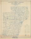
| Description: | Shows routes, post offices, schools, churches, houses, roads, and collection boxes of the rural delivery service of Manitowoc County. Bottom margins read:... |
If you didn't find the material you searched for, our Library Reference Staff can help.
Call our reference desk at 608-264-6535 or email us at:
