 Filter: Categories of Wisconsin Historical Images
Filter: FULL_DATE of 1911
Filter: Subject of rivers
Filter: Categories of Wisconsin Historical Images
Filter: FULL_DATE of 1911
Filter: Subject of rivers
| Date: | 1911 |
|---|---|
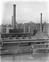
| Description: | International Harvester's McCormick Works on the river with railroad tracks and a cargo dock. The factory was owned by the McCormick Harvesting Machine Com... |
| Date: | 1911 |
|---|---|
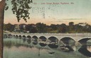
| Description: | View from shoreline toward the bridge. Caption reads: "John Street Bridge, Appleton, Wis." |
| Date: | 1911 |
|---|---|
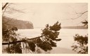
| Description: | Winter scene, probably along the Wisconsin River, possibly near Taliesin, the home of Frank Lloyd Wright. Taliesin is located in the vicinity of Spring Gre... |
| Date: | 1911 |
|---|---|
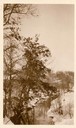
| Description: | Winter scene with stream and snow-covered trees, probably near Taliesin, the home of Frank Lloyd Wright. Wright dammed the stream to supply water to Talie... |
| Date: | 1911 |
|---|---|
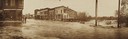
| Description: | View of Main and Water Streets while experiencing severe flooding. |
| Date: | 1911 |
|---|---|
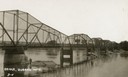
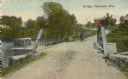
| Description: | View towards the bridge along the left. Trees are along the opposite shoreline. Caption reads: "Bridge, Durand Wis." |

| Date: | 1911 |
|---|---|
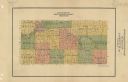
| Description: | Plat Map of Blooming Grove in "Atlas of Dane County, Wisconsin." |
| Date: | 1911 |
|---|---|
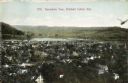
| Description: | Elevated view of town, with a river and hills in the background. Caption reads: "Panoramic View, Richland Center, Wis." |
| Date: | 1911 |
|---|---|
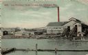
| Description: | Log entrance of the Paine Lumber Co. Edward L. Paine founded the lumber mill in 1853 on the east bank of the Fox River. Caption reads: "Log Entrance, Paine... |
| Date: | 1911 |
|---|---|
| Description: | Man and dog standing near bridge. Buildings in background. There is a boat on the left on the water near the bridge. Caption reads: "Bridge, Okauchee, Wis.... |

| Date: | 1911 |
|---|---|
| Description: | Buildings in high flood water, and floating near the powerhouse spillway. |

| Date: | 1911 |
|---|---|
| Description: | A map of the village of Black Earth and Verona. |
| Date: | 1911 |
|---|---|
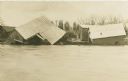
| Description: | View across river of several collapsing buildings on the edge of flooded river banks, during the flood. |

| Date: | 1911 |
|---|---|
| Description: | A business atlas map of Wisconsin, showing the railroads, counties, cities, villages, rivers, lakes, electric lines, and steamship lines in the state. Othe... |
| Date: | 1911 |
|---|---|
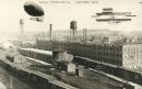
| Description: | Photographic postcard view of the Kissel Motor Car Company. The elevated view shows the factory buildings, water towers, railroad cars and track. A dirigib... |

| Date: | 1911 |
|---|---|
| Description: | This map of Wisconsin, the western portion of Michigan's Upper Peninsula, and northern Illinois shows counties, towns, cities and villages, rivers and lake... |

| Date: | 1911 |
|---|---|
| Description: | View across water of trees and wooden buildings submerged in water, probably during the 1911 (or 1905) flood of the Black River. |

| Date: | 1911 |
|---|---|
| Description: | A map of the Racine, Kenosha, and portions of Milwaukee counties, that shows the townships in Racine and Kenosha, and the townships of Brookfield, New Berl... |
| Date: | 1911 |
|---|---|
| Description: | Map shows townships and sections, roads, and railroads. "W.W. Downs, attorney-at-law, Eau Claire, Wis." |
If you didn't find the material you searched for, our Library Reference Staff can help.
Call our reference desk at 608-264-6535 or email us at:
