 Filter: Categories of Wisconsin Historical Images
Filter: FULL_DATE of 1911
Filter: Subject of human settlements
Filter: Categories of Wisconsin Historical Images
Filter: FULL_DATE of 1911
Filter: Subject of human settlements

| Date: | 1911 |
|---|---|
| Description: | This map shows ward numbers, streets, railroads, electric car lines, parks, steam railways, section numbers, Lake Michigan and one mile concentric circles ... |

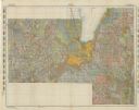
| Date: | 1911 |
|---|---|
| Description: | This map shows city wards, block numbers, parks, cemeteries, roads, railroads, Lake Michigan, and selected buildings. Also included are indexes "Milwaukee ... |

| Date: | 1911 |
|---|---|
| Description: | This map shows plat of town, local streets, numbered lots, blocks, and wards, roads, Lake Menomin, Wilson Creek, Red Cedar River, and land ownership by nam... |

| Date: | 1911 |
|---|---|
| Description: | View across Main Street, between First and Water Streets. Businesses include A.H. Hagen & Son on the left, and C.E. Mower on the right. A lamppost is in th... |

| Date: | 1911 |
|---|---|
| Description: | This map shows the soil types of towns and counties. A key of soil types is included with yellow, blue, brown, pink, orange, green, and gray. The top left ... |

| Date: | 1911 |
|---|---|
| Description: | Elevated view of the erosion caused by the 1911 Flood in Black River Falls. Houses are hanging off the edge of the river. |

| Date: | 1911 |
|---|---|
| Description: | View along shoreline of the Black River after the 1911 flood. The banks are eroded, and power lines are downed. |

| Date: | 1911 |
|---|---|
| Description: | View of a bridge damaged by the 1911 flood. Debris is scattered in the foreground. |

| Date: | 1911 |
|---|---|
| Description: | Elevated view of the Black River after the 1911 flood. Severely eroded banks are on the left. |
| Date: | 1911 |
|---|---|
| Description: | This map shows soil types, lakes, rivers, and railroads. A key of soil profiles and a legend of soil types is included. The bottom margin reads: "Soils su... |

| Date: | 1911 |
|---|---|
| Description: | This map shows swamps, railroads, rivers, roads, the Catholic Mission Reserve, the day school, and the Agency Reserve. Lake Superior is labeled. An inset m... |

| Date: | 1911 |
|---|---|
| Description: | View along eroded shoreline of the damage from the 1911 flood of the Black River. A city street had been washed away. Three men are looking at the river. |

| Date: | 1911 |
|---|---|
| Description: | Elevated view of damage to buildings after the 1911 flood of the Black River. Wooden debris is floating in the flood water and encroaching the shoreline. |

| Date: | 1911 |
|---|---|
| Description: | Elevated view across the high water on the Black River towards the town of Black River Falls. There is a large amount of wooden debris floating in the rive... |

| Date: | 1911 |
|---|---|
| Description: | View along shoreline of damage from the 1911 flood of the Black River. An entire wall of a building is gone, and debris is along the river banks. |

| Date: | 1911 |
|---|---|
| Description: | Elevated view of buildings, a railroad bridge, and in the foreground people standing on what may be a dam over the river. |

| Date: | 1911 |
|---|---|
| Description: | Photographic postcard view across railroad tracks of Chicago, Milwaukee and St. Paul Railroad Depot on Felland Road. |

| Date: | 1911 |
|---|---|
| Description: | Photographic postcard view of Burke Union Church on Felland Road. Behind the building on the right is a shed. The church was torn down in the 1920s. This b... |

| Date: | 1911 |
|---|---|
| Description: | This map shows lakes, rivers, swamps, state swamp land, trails and railroads. Includes a township diagram. |
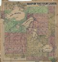
| Date: | 1911 |
|---|---|
| Description: | This hand-colored map shows landownership, rural dwellings, parks, roads, and railroads. Lake Mendota, Monona, Waubesa, and Kegonsa are labeled. |
If you didn't find the material you searched for, our Library Reference Staff can help.
Call our reference desk at 608-264-6535 or email us at: