 Filter: Categories of Wisconsin Historical Images
Filter: FULL_DATE of 1911
Filter: Subject of human settlements
Filter: Categories of Wisconsin Historical Images
Filter: FULL_DATE of 1911
Filter: Subject of human settlements
| Date: | 1911 |
|---|---|
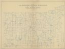
| Description: | Map shows routes, post offices, houses, churches, schools, and roads of La Fayette County rural delivery service. The map margins read: "G. January 11, 191... |

| Date: | 1911 |
|---|---|
| Description: | View looking down between railroad tracks towards the depot with an oncoming freight train on a third track on the far left. A group of people are standing... |

| Date: | 1911 |
|---|---|
| Description: | View down Center Street. The caption on the image is incorrect. On the left are storefronts, including a millinery and stable. On the right, commercial bui... |

| Date: | 1911 |
|---|---|
| Description: | A view of the depot and yards. A windmill and water tower in the distance. Carts with sacks of flour and milk cans next to the depot. Signs for Western Uni... |

| Date: | 1911 |
|---|---|
| Description: | A view of the central business district in a rural community. A group of people on the landing of a store. A cart with a pair of horses at hitching post. |

| Date: | 1911 |
|---|---|
| Description: | Three-quarter view of the Methodist Evangelical Church on a hillside. It has a belfry with no steeple and windows shaped like elongated pentagons. |

| Date: | 1911 |
|---|---|
| Description: | Map shows in blue roads, railroads, post offices, schools, houses, churches, and routes. The map includes a chart of "Explanation" that acts as a legend. T... |

| Date: | 1911 |
|---|---|
| Description: | View down street towards the a central business district. There is a T intersection at the end of the main street. Storefronts with awnings line both sides... |
| Date: | 1911 |
|---|---|
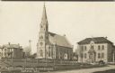
| Description: | Photographic postcard view of the church, with a parsonage on the left and a school on the right. A fenced-in field is across the street and an automobile ... |
| Date: | 1911 |
|---|---|
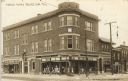
| Description: | Photographic postcard of an exterior view from the street of the Masonic Temple on a corner. The Peter Pfeffer haberdasher shop is on the ground floor at t... |

| Date: | 1911 |
|---|---|
| Description: | Colorized postcard of an elevated view across a dam towards a factory on the Rock River. Dwellings are on the far bank on the right. Caption reads: "The Da... |

| Date: | 1911 |
|---|---|
| Description: | Photographic postcard view of a street scene. Groups of people are gathered along the sidewalks near storefronts. A building on the left has a painted sign... |

| Date: | 1911 |
|---|---|
| Description: | Photographic postcard view of the devastation after a flood in central Black River Falls. Caption reads: "Where City Once Stood - Business Section." |
| Date: | 1911 |
|---|---|
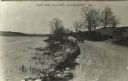
| Description: | View of an automobile driving down a road bordering a pond on the left. On the right is fencing and a wooden gate and a hill. Caption reads: "Driving Along... |

| Date: | 1911 |
|---|---|
| Description: | The title page of the "Atlas of Dane County, Wisconsin." |

| Date: | 1911 |
|---|---|
| Description: | This map of Duluth and Superior shows street car routes, railroads, ferries, some points of interest, and lighthouses. The bottom left of the map reads: "C... |
| Date: | 1911 |
|---|---|
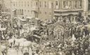
| Description: | Elevated view of circus parade with "UNITED STATES" tableau wagon passing through a crowded street intersection. |
| Date: | 1911 |
|---|---|
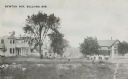
| Description: | View across field of Newton Avenue. A group of people are posed in the field near trees, and houses are line the avenue on the left and right. Caption read... |

| Date: | 1911 |
|---|---|
| Description: | Composite photograph of a trolley traversing Hillsboro's Main Street. Hillsboro did not actually have a streetcar; the image of the trolley was taken from ... |

| Date: | 1911 |
|---|---|
| Description: | View across river of buildings along the river's edge. Identified as probably Melrose or Northbend, not Black River Falls. Probably from the flood of 1911. |
If you didn't find the material you searched for, our Library Reference Staff can help.
Call our reference desk at 608-264-6535 or email us at: