 Filter: Categories of Wisconsin Historical Images
Filter: FULL_DATE of 1911
Filter: County of Dane
Filter: Creator Name of Anson, O. H. S. G. (Octavius Henry St. George)
Filter: Categories of Wisconsin Historical Images
Filter: FULL_DATE of 1911
Filter: County of Dane
Filter: Creator Name of Anson, O. H. S. G. (Octavius Henry St. George)
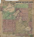
| Date: | 1911 |
|---|---|
| Description: | This hand-colored map shows landownership, rural dwellings, parks, roads, and railroads. Lake Mendota, Monona, Waubesa, and Kegonsa are labeled. |
If you didn't find the material you searched for, our Library Reference Staff can help.
Call our reference desk at 608-264-6535 or email us at:
