 Filter: Categories of Wisconsin Historical Images
Filter: FULL_DATE of 1911
Filter: Type of Map or Atlas
Filter: Categories of Wisconsin Historical Images
Filter: FULL_DATE of 1911
Filter: Type of Map or Atlas

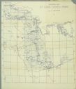
| Date: | 1911 |
|---|---|
| Description: | This map shows lakes, rivers, swamps, state swamp land, trails and railroads. Includes a township diagram. |

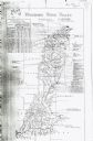
| Date: | 1911 |
|---|---|
| Description: | This map shows railroads, roads, swamps, a school site and farm, and a mill site. The map includes a "typical township" diagram. Lac du Flambeau, Long Lake... |
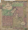
| Date: | 1911 |
|---|---|
| Description: | This hand-colored map shows landownership, rural dwellings, parks, roads, and railroads. Lake Mendota, Monona, Waubesa, and Kegonsa are labeled. |
| Date: | 1911 |
|---|---|
| Description: | This map includes references to reservoirs, industrial sites, and drainage basins. |

| Date: | 1911 |
|---|---|
| Description: | This map shows streets, railroads, the city house numbering system, and the Rock River. The left margin includes a street index. |
| Date: | 1911 |
|---|---|
| Description: | A map of St. Louis County, Minnesota that traces the route of Howard Green and The Gang's canoe trip from Tower to Ranier. |
If you didn't find the material you searched for, our Library Reference Staff can help.
Call our reference desk at 608-264-6535 or email us at: