Filter: Categories of Wisconsin Historical Images
Filter: FULL_DATE of 1910
Filter: Subject of persons
Filter: Subject of botany
Filter: County of Columbia
Filter: Categories of Wisconsin Historical Images
Filter: FULL_DATE of 1910
Filter: Subject of persons
Filter: Subject of botany
Filter: County of Columbia

| Date: | 1910 |
|---|---|
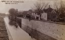
| Description: | View down the canal, with buildings along the shoreline, and a boat coming down the canal. |

| Date: | 1910 |
|---|---|
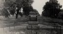
| Description: | Elevated view of cattle yards near the railroad tracks. A farm and farm buildings can be seen in the background. |
| Date: | 1910 |
|---|---|
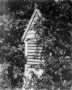
| Description: | Small wooden structure with what looks to be ventilation grating, obscured by foliage. |
| Date: | 1910 |
|---|---|
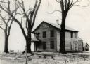
| Description: | Dell House, built in 1828 by Robert Allen in the vicinity of the Wisconsin Dells. This Inn was later operated by the J.B. McCuen Family. It burned down som... |
| Date: | 1910 |
|---|---|
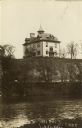
| Description: | View across water towards a high school on a hill in Lodi. |
| Date: | 1910 |
|---|---|
| Description: | A view of the Jacques Marquette and Louis Joliet marker. "This tablet marks the place near which Jacques Marquette and Louis Joliet entered the Wisconsin R... |
| Date: | 1910 |
|---|---|
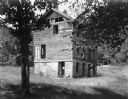
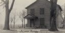
| Description: | A view of the Indian Agency House, before restoration. Built in 1832. |
| Date: | 1910 |
|---|---|
| Description: | The Indian Agency House, before restoration. This house built in 1832 by the United States Government. Restored by Colonial Dames between 1929-1932. |

| Date: | 1910 |
|---|---|
| Description: | The Portage Canal, dug by hand in 1849 and completed in 1851. It was renovated by the Army Corps of Engineers after the Civil War. |
| Date: | 1910 |
|---|---|
| Description: | The Portage Canal at the Wisconsin River, showing the upper lock. Caption reads: "Upper Lock and Wisconsin River Portage Wis. No. 10". A group of people ar... |
| Date: | 1910 |
|---|---|
| Description: | View from bank of the Wisconsin River of the Jaws of the Dells in winter. Snow is on the ground and ice lines the shoreline. |
| Date: | 1910 |
|---|---|
| Description: | The Locks and Jaws of the Dells in winter, taken at Devil's Elbow. The roof of the Larks Hotel, with the hotel's name on it, is visible in the background. |
| Date: | 1910 |
|---|---|
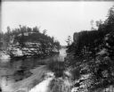
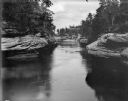
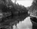
| Description: | A view of the rock formations along the Wisconsin River at the Dells. |
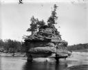
| Date: | 1910 |
|---|---|
| Description: | View across Wisconsin River of men and women in canoes at the base of Lone Rock at the Dells. |
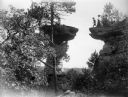
| Date: | 1910 |
|---|---|
| Description: | A man in motion moves toward making the leap to Stand Rock as men and women watch nearby. |
| Date: | 1910 |
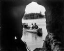
|---|---|
| Description: | A man paddles a canoe with four women passengers, as seen from inside Lone Rock Cave at the Dells. The far shoreline can be seen in the background. |
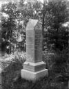
| Date: | 1910 |
|---|---|
| Description: | The Staudenmayer grave marker set amid the lush vegetation of Durwards Glen. |
| Date: | 1910 |
|---|---|
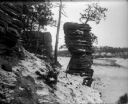
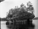
| Description: | The rock formation at the Dells known as the Sugar Bowl. |
| Date: | 1910 |
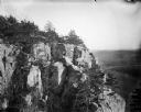
|---|---|
| Description: | View of the face of the bluff at Gibraltar Rock, with farmland and other bluffs far below in the distance. |
If you didn't find the material you searched for, our Library Reference Staff can help.
Call our reference desk at 608-264-6535 or email us at: