Filter: Categories of Wisconsin Historical Images
Filter: FULL_DATE of 1910
Filter: Subject of cities and towns
Filter: County of Ashland
Filter: Categories of Wisconsin Historical Images
Filter: FULL_DATE of 1910
Filter: Subject of cities and towns
Filter: County of Ashland
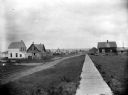
| Date: | 1910 |
|---|---|
| Description: | Looking west down wooden sidewalk along La Pointe's unpaved main street. |

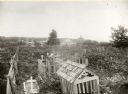
| Date: | 1910 |
|---|---|
| Description: | View of La Pointe taken from Big Bay Road on Madeline Island. |
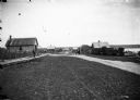
| Date: | 1910 |
|---|---|
| Description: | Looking down La Pointe's main street on Madeline Island. A man is walking on the board sidewalk on the left, and another person is driving a horse-drawn ve... |
| Date: | 1910 |
|---|---|
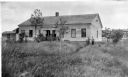
| Description: | George F. Thomas is holding a child and standing next to Edward F. Hansen in front of Treaty Hall in La Pointe on Madeline Island. |
| Date: | 1910 |
|---|---|
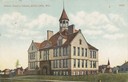
| Description: | The Beaser Avenue School, built in 1899 of brick and brownstone in the Richardson Romanesque style. In the background are dwellings and a church building. ... |
| Date: | 1910 |
|---|---|
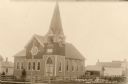
| Description: | Front view of Evangelical Church with neighboring houses. |
| Date: | 1910 |
|---|---|
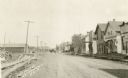
| Description: | View down unpaved East Main Street, with lumber stacked along the roadside on the left, and on the right storefronts are lining the street. A horse-drawn v... |
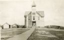
| Date: | 1910 |
|---|---|
| Description: | Front entrance to the public school in Butternut. A wooden sidewalk leads up to the entrance, where a |
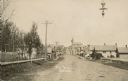
| Date: | 1910 |
|---|---|
| Description: | View of Main Street when it was a dirt road. A church is in the background, and telephone poles are along the left side of the road. A streetlight is hangi... |

| Date: | 1910 |
|---|---|
| Description: | View over railroad tracks of railway depot. Men are standing around the station, and carts are parked on the station platform. |

| Date: | 1910 |
|---|---|
| Description: | This map shows the locations of school houses, farms, roads, railroads, and Bad River Indian Reservation. Relief is shown by hachures. Yellow and red manus... |
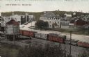
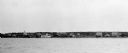
| Date: | 1910 |
|---|---|
| Description: | Elevated view of central Mellen from across the railroad yard. A freight train with logs is on the tracks. |
If you didn't find the material you searched for, our Library Reference Staff can help.
Call our reference desk at 608-264-6535 or email us at: