 Filter: Categories of Wisconsin Historical Images
Filter: FULL_DATE of 1910
Filter: Subject of cities and towns
Filter: Type of Map or Atlas
Filter: Categories of Wisconsin Historical Images
Filter: FULL_DATE of 1910
Filter: Subject of cities and towns
Filter: Type of Map or Atlas

| Date: | 1910 |
|---|---|
| Description: | Shows land for sale by Rusk Farm Co. in Rusk and Chippewa Counties, as well as farmhouses, roads, and railroads. |
| Date: | 1910 |
|---|---|
| Description: | This map from around 1916 shows the Soo Line railroad lines on a soil map of the state of Wisconsin. The map on the verso shows the township and range grid... |

| Date: | 1910 |
|---|---|
| Description: | This map is ink on paper. Shows Bruce’s proposed railway route and Moon’s railroad survey route along the Flambeau River, in parts of Lake and Eisenstein t... |
| Date: | 1910 |
|---|---|
| Description: | Shows roads, railroads, post offices, schools, houses, churches, and routes. Includes distant chart and explanation. "Price 35 cents"--Upper left margin. "... |

| Date: | 1910 |
|---|---|
| Description: | Shows existing and proposed parks, railroads, and marshes in a color coded key. "Contour interval 20 feet." Lake Wingra, Lake Mendota, and Lake Monona are ... |

| Date: | 1910 |
|---|---|
| Description: | Map shows routes, post offices, churches, schools, houses, and roads on the rural delivery service route in blue lines. An explanation key appears on the l... |

| Date: | 1910 |
|---|---|
| Description: | This map of Stevens Point shows the Wisconsin River, labeled plat additions, numbered lots, and some land ownership. An inset map in the bottom left corner... |

| Date: | 1910 |
|---|---|
| Description: | This map is ink and pen on tracing cloth and shows plat of the town, local streets, county roads, railroads, school houses, town halls, hotels, sheds, barn... |

| Date: | 1910 |
|---|---|
| Description: | This map is a survey of Kenosha Harbor and shows local streets, public buildings, local businesses, and part of Lake Michigan. Included is text on sailing ... |

| Date: | 1910 |
|---|---|
| Description: | This maps is pen and pencil on tracing cloth and shows local streets, buildings, proposed and present branches of railroad track, and sewer and water lines... |

| Date: | 1910 |
|---|---|
| Description: | This ink on paper blue line print base map consists of eight separate pieces and shows city limits, The Milwaukee Electric Railroad & Light Company lines, ... |

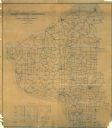
| Date: | 1910 |
|---|---|
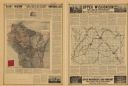
| Description: | This map shows counties, roads, Lake Superior, Lake Michigan, and portions of surrounding states. Also included is a list of railroads showing miles and gr... |

| Date: | 1910 |
|---|---|
| Description: | This map shows counties, roads, Lake Superior, Lake Michigan, and portions of surrounding states. Included is a table of interstate and intrastate railroa... |

| Date: | 1910 |
|---|---|
| Description: | This map shows shoreline lot numbers and acreages, the Wisconsin River, and the Michigan and Wisconsin state line. Manuscript annotations relating to topon... |

| Date: | 1910 |
|---|---|
| Description: | This map shows the locations of school houses, farms, roads, railroads, and Bad River Indian Reservation. Relief is shown by hachures. Yellow and red manus... |

| Date: | 1910 |
|---|---|
| Description: | This blue print map shows original lakes, area to be covered by Chippewa Flowage (flow-lines for contours 1310 and 1315), dam sites, roads, and buildings. |

| Date: | 1910 |
|---|---|
| Description: | A Sanborn insurance map of a section of Milwaukee, including East Clybourn and East Buffalo Streets. "Italian Section 3/4/30" is written on the page in blu... |

| Date: | 1910 |
|---|---|
| Description: | A Sanborn insurance map of Milwaukee, including the shore of Lake Michigan. |

| Date: | 1910 |
|---|---|
| Description: | This blueprint plat map shows the plan of lots and streets on a Madison hill south of Lake Monona. Includes annotations showing land prices in pencil. |

| Date: | 1910 |
|---|---|
| Description: | This map of shows railway lines in red, with railroad land grant in Taylor, Price, and Ashland Counties shaded red, on top of the cities, counties, highway... |
If you didn't find the material you searched for, our Library Reference Staff can help.
Call our reference desk at 608-264-6535 or email us at: