Filter: Categories of Wisconsin Historical Images
Filter: FULL_DATE of 1910
Filter: Type of Map or Atlas
Filter: County of Dodge
Filter: Categories of Wisconsin Historical Images
Filter: FULL_DATE of 1910
Filter: Type of Map or Atlas
Filter: County of Dodge

| Date: | 1910 |
|---|---|
| Description: | Left half of a plat map of Hustisford in Dodge County. |

| Date: | 1910 |
|---|---|
| Description: | The right half of a plat map of Hustisford in Dodge County. |

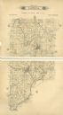
| Date: | 1910 |
|---|---|
| Description: | A land ownership map of the township of Leroy. |
If you didn't find the material you searched for, our Library Reference Staff can help.
Call our reference desk at 608-264-6535 or email us at: