 Filter: Categories of Wisconsin Historical Images
Filter: FULL_DATE of 1909
Filter: Subject of transportation
Filter: Subject of lakes
Filter: Categories of Wisconsin Historical Images
Filter: FULL_DATE of 1909
Filter: Subject of transportation
Filter: Subject of lakes

| Date: | 1909 |
|---|---|
| Description: | View from the University of Wisconsin service building smokestack of south Madison, including Mills Street, Mound Street, and the Greenbush. Lake Monona is... |
| Date: | 1909 |
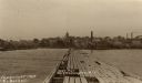
|---|---|
| Description: | View down Government Pier. In the distance are industrial buildings along the shoreline. Caption reads: "Gov't Pier Port Washington, Wis." |
| Date: | 1909 |
|---|---|
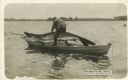
| Description: | Photomontage of a man pulling a giant fish into his rowboat. As the text box in the lower left corner--which reads "Swallowed The Pole and All"--suggests,... |

| Date: | 1909 |
|---|---|
| Description: | Elevated view over University Avenue towards the northeast of Bascom Hall and Lake Mendota on the University of Wisconsin-Madison campus. The Chemistry Bui... |
| Date: | 1909 |
|---|---|
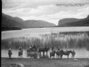
| Description: | Children standing on horses' backs posing for the photograph, alongside of a wagon, and other horseback riders, on the shore of Vaseaux Lake. Caption reads... |
| Date: | 1909 |
|---|---|
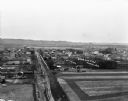
| Description: | An elevated view of a town in the Wisconsin River Valley. Fields surround the town, and low hills are in the far background. |

| Date: | 1909 |
|---|---|
| Description: | Map of Sawyer County with an advertisement for land sales through Fuley & Quail of Hayward, Wisconsin. There is a small inset map of railroads accessible i... |

| Date: | 1909 |
|---|---|
| Description: | A brochure with a map showing the North-Western Railway lines from northern Illinois, starting at Chicago, to southeastern Wisconsin, stopping at Sheboygan... |
| Date: | 1909 |
|---|---|
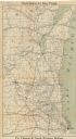
| Description: | This map shows the Chicago and North Western Railway lines in eastern Wisconsin, north to Wausau and Oconto and west to Baraboo and Blue Mounds, and northe... |

| Date: | 1909 |
|---|---|
| Description: | A map of Langlade County, Wisconsin that shows townships and ranges, towns, cities and villages, wagon roads, churches, schools, sawmills, town halls, chee... |

| Date: | 1909 |
|---|---|
| Description: | This 1909 revision of Harmon's 1896 map of Washburn County, Wisconsin, shows the township and range grid, towns, sections, schools, wagon roads, cities and... |

| Date: | 1909 |
|---|---|
| Description: | This 1909 bird's-eye view of Madison and the surrounding Four Lakes region shows roads, railroads, selected buildings in Madison, and points of interest ar... |

| Date: | 1909 |
|---|---|
| Description: | This 1909 map of northern Wisconsin and a portion of Michigan's Upper Peninsula shows the Lac du Flambeau Indian Reservation, cities and villages, railroad... |

| Date: | 1909 |
|---|---|
| Description: | Streets, Lake Wingra, Lake Mendota, and Lake Monona are all labelled. Map reads: "The present park system of Madison comprises 150 acres of improved parks,... |

| Date: | 1909 |
|---|---|
| Description: | This map of Duluth and Superior was issued by the Duluth Street Railway Company and shows street railway routes in the cities, as well as lakes, bays, harb... |

| Date: | 1909 |
|---|---|
| Description: | Photographic postcard across water, showing launch owned by Schlitz Brewery of Milwaukee operating on Stone Lake. Caption reads: "Stone Lake, Crandon, Wis.... |

| Date: | 1909 |
|---|---|
| Description: | This map covers Iron and Price Counties and portions of Sawyer and Oneida Counties. The map shows vacant and sold Wis. Central Ry. land, settlers houses, s... |

| Date: | 1909 |
|---|---|
| Description: | Bird's-eye view of Lake Geneva from the south extending to Waukesha and Milwaukee in the north. Delavan Lake and Lake Como are identified. Several electric... |

| Date: | 1909 |
|---|---|
| Description: | Hand-colored view across water of three, two-person sailboats on Cedar Lake. On the far shoreline are buildings at the top of a hill. Caption reads: "Yacht... |
If you didn't find the material you searched for, our Library Reference Staff can help.
Call our reference desk at 608-264-6535 or email us at:
