 Filter: Categories of Wisconsin Historical Images
Filter: FULL_DATE of 1909
Filter: Subject of transportation
Filter: Subject of education
Filter: Categories of Wisconsin Historical Images
Filter: FULL_DATE of 1909
Filter: Subject of transportation
Filter: Subject of education
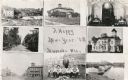
| Date: | 1909 |
|---|---|
| Description: | Composite of views of Muscoda including: Electric Light plant, Smalley House, St. John Catholic Church, Lover's Lane, Muscoda Public School, Wisconsin Aven... |
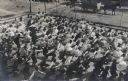
| Date: | 1909 |
|---|---|
| Description: | Elevated view of a large group of school children exercising in the schoolyard. Boys and girls are on separate sides of the yard. All are the students are ... |

| Date: | 1909 |
|---|---|
| Description: | View across road of school children and a man and a woman standing in front of the two-story public school. There is a bell tower above the entrance. A num... |

| Date: | 1909 |
|---|---|
| Description: | A map of Langlade County, Wisconsin that shows townships and ranges, towns, cities and villages, wagon roads, churches, schools, sawmills, town halls, chee... |

| Date: | 1909 |
|---|---|
| Description: | This 1909 map of Taylor County, Wisconsin, shows the township and range grid, towns, sections, cities and villages, settlers houses, schools, churches, saw... |

| Date: | 1909 |
|---|---|
| Description: | This 1909 revision of Harmon's 1896 map of Washburn County, Wisconsin, shows the township and range grid, towns, sections, schools, wagon roads, cities and... |

| Date: | 1909 |
|---|---|
| Description: | View across lawn of the high school, which is a two and a half story brick building, and on the roof is a large round metal vent, and a belfry with a coppe... |

| Date: | 1909 |
|---|---|
| Description: | Colorized postcard of the exterior view of a high school. Students are sitting on the front steps. Caption reads: "High School, Beloit, Wis." |

| Date: | 1909 |
|---|---|
| Description: | This map shows vacant Wisconsin Central Ry. lands, settlers houses, lands sold by Wisconsin Central Ry., schools, churches, saw mills, and roads; also show... |

| Date: | 1909 |
|---|---|
| Description: | This map covers Iron and Price Counties and portions of Sawyer and Oneida Counties. The map shows vacant and sold Wis. Central Ry. land, settlers houses, s... |
If you didn't find the material you searched for, our Library Reference Staff can help.
Call our reference desk at 608-264-6535 or email us at: