 Filter: Categories of Wisconsin Historical Images
Filter: FULL_DATE of 1909
Filter: Subject of superior, lake
Filter: Categories of Wisconsin Historical Images
Filter: FULL_DATE of 1909
Filter: Subject of superior, lake

| Date: | 1909 |
|---|---|
| Description: | Postcard of the overhanging cliffs near the stone quarry on Presque Isle or Stockton Island's. Caption reads: "Apostle Islands, Wis. Presque Isle or Stockt... |

| Date: | 1909 |
|---|---|
| Description: | This 1909 chart of the Apostle Islands, Chequamegon Bay, and the Lake Superior shoreline shows relief by contours and spot heights and depths by contours, ... |

| Date: | 1909 |
|---|---|
| Description: | This map of Duluth and Superior was issued by the Duluth Street Railway Company and shows street railway routes in the cities, as well as lakes, bays, harb... |

| Date: | 1909 |
|---|---|
| Description: | This map shows Duluth, Minnesota and Superior, Wisconsin, and portions of Saint Louis County, Minnesota and Douglas County, Wisconsin. Water depth is shown... |

| Date: | 1909 |
|---|---|
| Description: | This map covers Iron and Price Counties and portions of Sawyer and Oneida Counties. The map shows vacant and sold Wis. Central Ry. land, settlers houses, s... |
| Date: | 1909 |
|---|---|
| Description: | A cyanoprint map of The Gang's journey down the Presque Isle River. There are small drawings around the border depicting the adventures of The Gang and Car... |

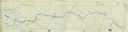
| Date: | 1909 |
|---|---|
| Description: | A hand-drawn and illustrated map of The Gang's trip from their seventh camp to Lake Superior. |
If you didn't find the material you searched for, our Library Reference Staff can help.
Call our reference desk at 608-264-6535 or email us at:
