 Filter: Categories of Wisconsin Historical Images
Filter: FULL_DATE of 1908
Filter: Subject of streams
Filter: Categories of Wisconsin Historical Images
Filter: FULL_DATE of 1908
Filter: Subject of streams
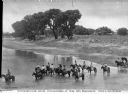
| Date: | 1908 |
|---|---|
| Description: | Elevated view of men and women on horseback in a strem. On the shoreline at the right is a horse-drawn carriage . Trees are further down the shoreline, and... |

| Date: | 1908 |
|---|---|
| Description: | This early 20th century map shows the township and range system, sections, state-owned land, selected buildings and landownership, railroads, bridges, and ... |

| Date: | 1908 |
|---|---|
| Description: | This 1908 map shows the township and range grid, sections, towns, villages, railroads, bridges, lakes, streams, rapids, and state-owned lands in Oneida Cou... |
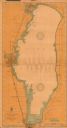
| Date: | 1908 |
|---|---|
| Description: | This 1908 chart from the U.S. Army Corps of Engineers shows contour and spot depths in Lake Winnebago. Cities and villages, roads, railroads, institutions ... |
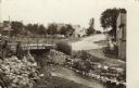
| Date: | 1908 |
|---|---|
| Description: | View of a street going through the center of town. In the foreground is a stream and a bridge. Commercial buildings and dwellings are on the left. |
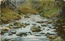
| Date: | 1908 |
|---|---|
| Description: | View of Sherman creek. Caption reads: "Sherman Creek, Eau Claire, Wis." |
If you didn't find the material you searched for, our Library Reference Staff can help.
Call our reference desk at 608-264-6535 or email us at:
