 Filter: Categories of Wisconsin Historical Images
Filter: FULL_DATE of 1908
Filter: Subject of schools
Filter: Categories of Wisconsin Historical Images
Filter: FULL_DATE of 1908
Filter: Subject of schools
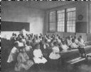
| Date: | 1908 |
|---|---|
| Description: | First and second grade students in their classroom at Scribner School. |
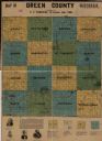
| Date: | 1908 |
|---|---|
| Description: | This map shows townships and sections, landownership, schools, and churches. Includes text explaining survey system. |

| Date: | 1908 |
|---|---|
| Description: | A map of Langlade County, Wisconsin that shows the townships and ranges, towns, cities and villages, wagon roads, churches, schools, lakes, rivers, railroa... |

| Date: | 1908 |
|---|---|
| Description: | This 1908 map shows the town and range grid, sections, cities and villages, acreages, settlers, schools, wagon roads, railroads, saw mills, and lakes, stre... |

| Date: | 1908 |
|---|---|
| Description: | This map shows counties, roads, Lake Superior, Lake Michigan, and portions of surrounding states. Also included is a list of railroads showing miles and g... |
If you didn't find the material you searched for, our Library Reference Staff can help.
Call our reference desk at 608-264-6535 or email us at: