 Filter: Categories of Wisconsin Historical Images
Filter: FULL_DATE of 1908
Filter: Subject of marshes
Filter: Categories of Wisconsin Historical Images
Filter: FULL_DATE of 1908
Filter: Subject of marshes
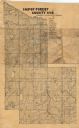
| Date: | 1908 |
|---|---|
| Description: | Map shows swamps, windfalls, roads and railroads. Status of some land marked (O, S, X) but lacks explanation. |

| Date: | 1908 |
|---|---|
| Description: | Title at top: "G.F. Sanborn Company Timber and Farming Lands." Map shows acreages, roads, railroads, and swamps in parts of Vilas and Oneida counties. |

| Date: | 1908 |
|---|---|
| Description: | View of a marshy part of Rock Lake. Two small rowboats and a pile of logs are on the shore, and a flock of ducks is in the water. Caption reads: "Hunting G... |
If you didn't find the material you searched for, our Library Reference Staff can help.
Call our reference desk at 608-264-6535 or email us at: