 Filter: Categories of Wisconsin Historical Images
Filter: FULL_DATE of 1908
Filter: Subject of lakes
Filter: Categories of Wisconsin Historical Images
Filter: FULL_DATE of 1908
Filter: Subject of lakes
| Date: | 1908 |
|---|---|
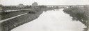
| Description: | The Yahara River from Williamson Street with Lake Monona in the background. House & Barn pictured is located at 601 Riverside Drive. |

| Date: | 1908 |
|---|---|
| Description: | Colored map showing a panoramic view of Madison in great detail. The Wisconsin State Capitol is located at the center, with Lake Mendota in the background ... |

| Date: | 1908 |
|---|---|
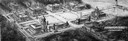
| Description: | A panoramic aerial view of the Isthmus taken from a kite. Lake Mendota is to the right in the background with Picnic Point jutting into the lake. The photo... |
| Date: | 1908 |
|---|---|
| Description: | Drawing of lower campus development of the University of Wisconsin Madison campus, designed by Arthur Peabody. Left to right along Lake Street are the Mus... |
| Date: | 1908 |
|---|---|
| Description: | Design of the Architectural Commission of 1908 for future constructional development, elevation of men's dormitory group on the University of Wisconsin cam... |

| Date: | 1908 |
|---|---|
| Description: | Drawing of the general design for future construction development at the University of Wisconsin with the Barn, Sheep Barn, Horse Barn, House, Power House,... |

| Date: | 1908 |
|---|---|
| Description: | General design for future construction development of the University of Madison campus with the general view of the campus by the Architectural commission. |
| Date: | 1908 |
|---|---|
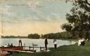
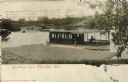
| Description: | View towards people standing on the shoreline near a boat landing at Yosts Park. A man and a dog are standing on the pier, and a group of people are in a b... |

| Date: | 1908 |
|---|---|
| Description: | Colored map in perspective indicates railroad routes. Lake Winnebago and Oshkosh in center, area extends to Shawano (top right corner), Green Bay (bottom r... |
| Date: | 1908 |
|---|---|
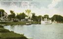
| Description: | View from shoreline towards a large boat, perhaps an excursion boat, and sailboats docked further down along the curving shoreline. Beyond the boats is a t... |
| Date: | 1908 |
|---|---|
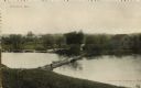
| Description: | Elevated view of lake and and a bridge road. A man is standing on the road, and a boat is pulled up near the bridge. There is a building on the opposite sh... |
| Date: | 1908 |
|---|---|
| Description: | View from shoreline towards a man on a boat on lake, and a bridge road in the background on the left. Caption reads: "Greetings from Okauchee, Wis." |

| Date: | 1908 |
|---|---|
| Description: | Aerial View of University of Wisconsin-Madison College of Agriculture. Lake Mendota with Picnic Point is in the background. |

| Date: | 1908 |
|---|---|
| Description: | Fraternity house, 644 N Frances Street, University of Wisconsin-Madison. Lake Mendota is in the background. |

| Date: | 1908 |
|---|---|
| Description: | A view of the Montello granite quarry with Montello Lake in the background. The sign in the foreground reads, "J.T. Barrett Pays Highest Prices for Furs, M... |

| Date: | 1908 |
|---|---|
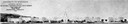
| Description: | Elevated view of the city of Rice Lake with a lumber yard in the foreground, a railroad and Rice Lake at left. Caption reads: "Rice Lake, Wisconsin." |
| Date: | 1908 |
|---|---|
| Description: | Photographic postcard view of Harriman Avenue in the residential district. A little girl is standing with her baby carriage on the sidewalk between a telep... |

| Date: | 1908 |
|---|---|
| Description: | A business map of Wisconsin, showing railroads, counties, cities, villages, rivers, and lakes. Additional areas shown in the map include the western portio... |

| Date: | 1908 |
|---|---|
| Description: | A map of Wisconsin showing cities and towns, rivers, lakes, and railroads. Other areas included in the map are the western portion of Michigan's Upper Pen... |
| Date: | 1908 |
|---|---|
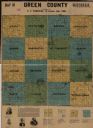
| Description: | This map shows townships and sections, landownership, schools, and churches. Includes text explaining survey system. |
If you didn't find the material you searched for, our Library Reference Staff can help.
Call our reference desk at 608-264-6535 or email us at: