 Filter: Categories of Wisconsin Historical Images
Filter: FULL_DATE of 1908
Filter: Subject of cities and towns
Filter: Categories of Wisconsin Historical Images
Filter: FULL_DATE of 1908
Filter: Subject of cities and towns
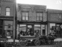
| Date: | 1908 |
|---|---|
| Description: | View from street of man seated on a horse-drawn wagon on Silver Street, which is parked in front of (from left to right) Joseph Rainieri Meat Market, Egan ... |

| Date: | 1908 |
|---|---|
| Description: | A business map of Wisconsin, showing railroads, counties, cities, villages, rivers, and lakes. Additional areas shown in the map include the western portio... |

| Date: | 1908 |
|---|---|
| Description: | A map of Wisconsin showing cities and towns, rivers, lakes, and railroads. Other areas included in the map are the western portion of Michigan's Upper Pen... |
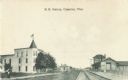
| Date: | 1908 |
|---|---|
| Description: | Black and white postcard of a railroad station across from the Hotel Wells. Railroad tracks run between them, disappearing into the distance. There are tre... |
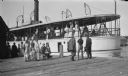
| Date: | 1908 |
|---|---|
| Description: | The photographer's family poses on the dock beside the ship "Sailor Boy" of Sturgeon Bay. Clothilde Hotz holds the hand of Ferdinand Leonard (Fedy); daught... |
| Date: | 1908 |
|---|---|
| Description: | This map shows townships and sections, landownership, schools, and churches. Includes text explaining survey system. |

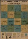
| Date: | 1908 |
|---|---|
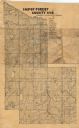
| Description: | A map of Langlade County, Wisconsin that shows the townships and ranges, towns, cities and villages, wagon roads, churches, schools, lakes, rivers, railroa... |

| Date: | 1908 |
|---|---|
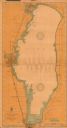
| Description: | A detailed map of Michigan Island and Gull Island in the Apostle Islands group (T51N, R1W, 4 M) that shows sections, landowners, the Michigan Island Lighth... |

| Date: | 1908 |
|---|---|
| Description: | This early 20th century map shows the township and range system, sections, state-owned land, selected buildings and landownership, railroads, bridges, and ... |

| Date: | 1908 |
|---|---|
| Description: | This 1908 map shows the township and range grid, sections, towns, villages, railroads, bridges, lakes, streams, rapids, and state-owned lands in Oneida Cou... |
| Date: | 1908 |
|---|---|
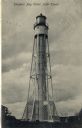
| Description: | Postcard view of the tower. Caption reads: "Sturgeon Bay Canal Light Tower." |

| Date: | 1908 |
|---|---|
| Description: | This 1908 map shows the town and range grid, sections, cities and villages, acreages, settlers, schools, wagon roads, railroads, saw mills, and lakes, stre... |
| Date: | 1908 |
|---|---|
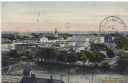
| Description: | Hand-colored postcard view overlooking a portion of the town. Caption reads: "A Portion of Kendalville, Ind." |
| Date: | 1908 |
|---|---|
| Description: | Map shows swamps, windfalls, roads and railroads. Status of some land marked (O, S, X) but lacks explanation. |
| Date: | 1908 |
|---|---|
| Description: | This 1908 chart from the U.S. Army Corps of Engineers shows contour and spot depths in Lake Winnebago. Cities and villages, roads, railroads, institutions ... |

| Date: | 1908 |
|---|---|
| Description: | Panoramic view of Madison taken from Summit Avenue looking East South East toward Lake Monona. Included in the view are the Camp Randall bleachers, St. Rap... |

| Date: | 1908 |
|---|---|
| Description: | Shows townships and sections, roads, and railroads. Includes list of towns, villages, and cities with organization dates. |

| Date: | 1908 |
|---|---|
| Description: | The map reads: "Feb. 3, 1908." Oriented with north to the lower left. Lake Monona, Monona Bay, and Brittingham Park are labelled. |

| Date: | 1908 |
|---|---|
| Description: | Shows pipes of various sizes, hydrants, valves, and wells. "1907" -- Lower margin. Lake Wingra, Lake Monona, and Lake Mendota are labelled. |

| Date: | 1908 |
|---|---|
| Description: | Map shows townships and sections, landownership and acreages, rural routes, roads, railroads, creameries, churches, schools, and town halls. Sections appea... |
If you didn't find the material you searched for, our Library Reference Staff can help.
Call our reference desk at 608-264-6535 or email us at: