 Filter: Categories of Wisconsin Historical Images
Filter: FULL_DATE of 1908
Filter: Subject of bird's-eye views
Filter: Categories of Wisconsin Historical Images
Filter: FULL_DATE of 1908
Filter: Subject of bird's-eye views

| Date: | 1908 |
|---|---|
| Description: | Colored map showing a panoramic view of Madison in great detail. The Wisconsin State Capitol is located at the center, with Lake Mendota in the background ... |

| Date: | 1908 |
|---|---|
| Description: | Colored map in perspective indicates railroad routes. Lake Winnebago and Oshkosh in center, area extends to Shawano (top right corner), Green Bay (bottom r... |

| Date: | 1908 |
|---|---|
| Description: | Elevated photographic postcard view of town showing homes and businesses. A windmill is in the foreground. The school is on the far edge of town on the lef... |
| Date: | 1908 |
|---|---|
| Description: | Colorized panoramic elevated view with the main commercial district in the center. The high school is on the far right. Caption reads: "Birds [sic] Eye Vie... |

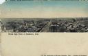
| Date: | 1908 |
|---|---|
| Description: | Elevated view of the skyline of central Janesville and surrounding landscape. Caption reads: "Bird's Eye [sic] View of Janesville, Wis." |
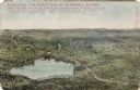
| Date: | 1908 |
|---|---|
| Description: | Illustrated postcard of Lake Winnebago and the surrounding communities. Text on front reads: "Looking northwest from the east shore of Lake Winnebago showi... |

| Date: | 1908 |
|---|---|
| Description: | Bird's-eye view showing Lake Mendota, Lake Monona, Lake Waubesa, Lake Wingra and Lake Kegonsa. Madison has only the isthmus developed, and there are settle... |

| Date: | 1908 |
|---|---|
| Description: | Birds-eye view of Mazomanie and the surrounding landscape. Caption reads: "Birds-Eye View Mazomanie, Wis." |
If you didn't find the material you searched for, our Library Reference Staff can help.
Call our reference desk at 608-264-6535 or email us at: