 Filter: Categories of Wisconsin Historical Images
Filter: FULL_DATE of 1908
Filter: Type of Map or Atlas
Filter: Categories of Wisconsin Historical Images
Filter: FULL_DATE of 1908
Filter: Type of Map or Atlas

| Date: | 1908 |
|---|---|
| Description: | Colored map showing a panoramic view of Madison in great detail. The Wisconsin State Capitol is located at the center, with Lake Mendota in the background ... |

| Date: | 1908 |
|---|---|
| Description: | Five volumes of the Crown Collection of American Maps, plus an index, showing the spines of these books. |
| Date: | 1908 |
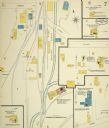
|---|---|
| Description: | Sanborn map, sheet 7, of a portion of Mineral Point. |

| Date: | 1908 |
|---|---|
| Description: | Colored map in perspective indicates railroad routes. Lake Winnebago and Oshkosh in center, area extends to Shawano (top right corner), Green Bay (bottom r... |

| Date: | 1908 |
|---|---|
| Description: | A business map of Wisconsin, showing railroads, counties, cities, villages, rivers, and lakes. Additional areas shown in the map include the western portio... |

| Date: | 1908 |
|---|---|
| Description: | A map of Wisconsin showing cities and towns, rivers, lakes, and railroads. Other areas included in the map are the western portion of Michigan's Upper Pen... |
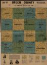
| Date: | 1908 |
|---|---|
| Description: | This map shows townships and sections, landownership, schools, and churches. Includes text explaining survey system. |

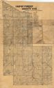
| Date: | 1908 |
|---|---|
| Description: | A map of Langlade County, Wisconsin that shows the townships and ranges, towns, cities and villages, wagon roads, churches, schools, lakes, rivers, railroa... |

| Date: | 1908 |
|---|---|
| Description: | A detailed map of Michigan Island and Gull Island in the Apostle Islands group (T51N, R1W, 4 M) that shows sections, landowners, the Michigan Island Lighth... |

| Date: | 1908 |
|---|---|
| Description: | This early 20th century map shows the township and range system, sections, state-owned land, selected buildings and landownership, railroads, bridges, and ... |

| Date: | 1908 |
|---|---|
| Description: | This 1908 map shows the township and range grid, sections, towns, villages, railroads, bridges, lakes, streams, rapids, and state-owned lands in Oneida Cou... |

| Date: | 1908 |
|---|---|
| Description: | This 1908 map shows the town and range grid, sections, cities and villages, acreages, settlers, schools, wagon roads, railroads, saw mills, and lakes, stre... |
| Date: | 1908 |
|---|---|
| Description: | Map shows swamps, windfalls, roads and railroads. Status of some land marked (O, S, X) but lacks explanation. |
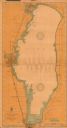
| Date: | 1908 |
|---|---|
| Description: | This 1908 chart from the U.S. Army Corps of Engineers shows contour and spot depths in Lake Winnebago. Cities and villages, roads, railroads, institutions ... |

| Date: | 1908 |
|---|---|
| Description: | Shows townships and sections, roads, and railroads. Includes list of towns, villages, and cities with organization dates. |

| Date: | 1908 |
|---|---|
| Description: | The map reads: "Feb. 3, 1908." Oriented with north to the lower left. Lake Monona, Monona Bay, and Brittingham Park are labelled. |

| Date: | 1908 |
|---|---|
| Description: | Shows pipes of various sizes, hydrants, valves, and wells. "1907" -- Lower margin. Lake Wingra, Lake Monona, and Lake Mendota are labelled. |

| Date: | 1908 |
|---|---|
| Description: | Map shows townships and sections, landownership and acreages, rural routes, roads, railroads, creameries, churches, schools, and town halls. Sections appea... |

| Date: | 1908 |
|---|---|
| Description: | Title at top: "G.F. Sanborn Company Timber and Farming Lands." Map shows acreages, roads, railroads, and swamps in parts of Vilas and Oneida counties. |

| Date: | 1908 |
|---|---|
| Description: | A detail of a Sanborn map showing the area around North Franklin, North Blair and North Hancock Streets. |
If you didn't find the material you searched for, our Library Reference Staff can help.
Call our reference desk at 608-264-6535 or email us at: