 Filter: Categories of Wisconsin Historical Images
Filter: FULL_DATE of 1907
Filter: Subject of cemeteries
Filter: Categories of Wisconsin Historical Images
Filter: FULL_DATE of 1907
Filter: Subject of cemeteries

| Date: | 1907 |
|---|---|
| Description: | This map shows ward numbers, streets, railroads, electric car lines, parks, steam railways, section numbers, Lake Michigan and one mile concentric circles ... |

| Date: | 1907 |
|---|---|
| Description: | This blueprint map shows a proposed plan for pleasure roads and reservation system. It also shows schools, cemeteries, old river channel, proposed bridge, ... |
| Date: | 1907 |
|---|---|
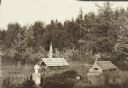
| Description: | A cemetery in an Indian village. There are flags and crosses, and over two of the graves are small wooden enclosures. |
| Date: | 1907 |
|---|---|
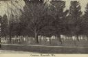
| Description: | Text on front reads: "Cemetery, Rosendale, Wis." A cemetery inside a chain link fence with mature trees. A sidewalk runs along the unpaved road in the fore... |
| Date: | 1907 |
|---|---|
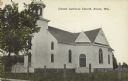
| Description: | Text on front reads: "United Lutheran Church. Strum, Wis." A clapboard church with gable decorations and a belfry. A fence surrounds the church with a ceme... |
If you didn't find the material you searched for, our Library Reference Staff can help.
Call our reference desk at 608-264-6535 or email us at: