 Filter: Categories of Wisconsin Historical Images
Filter: FULL_DATE of 1906
Filter: Categories of Wisconsin Historical Images
Filter: FULL_DATE of 1906

| Date: | 1906 |
|---|---|
| Description: | Black and white photographic postcard view of the Eau Claire River and shoreline. Caption reads: "Eau Claire River." |

| Date: | 1906 |
|---|---|
| Description: | Full-length studio portrait in front of a painted backdrop of Beulah Irene Miller dressed for her graduation from Evansville (Wisconsin) High School. Her l... |
| Date: | 1906 |
|---|---|
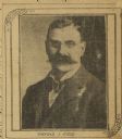
| Description: | Quarter-length portrait of Thomas Kidd, wearing eyeglasses and a suit and necktie. |
| Date: | 1906 |
|---|---|
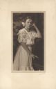
| Description: | A standing, three-quarter length studio portrait of Alma Schmidt at age 12. She is wearing a summer dress with cut-work decoration. She has a bow in her ha... |

| Date: | 1906 |
|---|---|
| Description: | This topographical map shows the Little Platte River, shafts, test-pits, old workings, contour lines of Galena limestone elevation, railroads, and building... |

| Date: | 1906 |
|---|---|
| Description: | This map shows ward boundaries, subdivisions, lot and block numbers and dimensions, house numbers, electric car lines, steam railways, and adjoining plat n... |

| Date: | 1906 |
|---|---|
| Description: | This map shows ward boundaries, lot and block numbers and dimensions, house numbers, electric car lines, steam railways, and adjoining plat numbers in a po... |

| Date: | 1906 |
|---|---|
| Description: | This map shows wards, schools, engine houses, railroads, street railways, block numbers, parks, roads, and Lake Michigan. Also included are indexes: Table ... |

| Date: | 1906 |
|---|---|
| Description: | This map shows streets, railroads, land use, public buildings, commercial businesses, and the Menominee River. Depths are shown by gradient tints and sound... |
| Date: | 1906 |
|---|---|
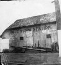
| Description: | Angle Worm Station, at the foot of South Carroll Street on Lake Monona. The signs on the building advertise: the "Dane County Fair," "Nichols Sells Souveni... |

| Date: | 1906 |
|---|---|
| Description: | This map shows miles to other islands, harbors, canals, and passages. The South Fox ISL. LT and the Black Gas Buoy are colored in yellow and red. Depths ar... |

| Date: | 1906 |
|---|---|
| Description: | This map shows railroads, rivers, bays, channels, shoreline and hydrography around Thunder Bay, Ontario. Depths are shown by soundings, isolines, and tints... |

| Date: | 1906 |
|---|---|
| Description: | This map shows bays, creeks, railroads and rivers. Relief is shown by contours and spot heights. Depths are shown by contours, tints, and soundings. Includ... |

| Date: | 1906 |
|---|---|
| Description: | Boys marching down a neighborhood street with toy guns. The leader is carrying a big stick. A boy in the back is carrying a flag. |
| Date: | 1906 |
|---|---|
| Description: | Watercolor painting of the Yahara River at Lake Monona. |
| Date: | 1906 |
|---|---|
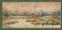
| Description: | Watercolor painting of the Yahara River at Lake Monona, with trees in the background and wetlands in the foreground. |
| Date: | 1906 |
|---|---|
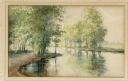
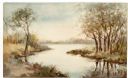
| Description: | Watercolor painting of the Yahara River, with large trees on the shoreline. Note: '05 & '06 were the years when Tenney Park and the Yahara River Parkway ... |
| Date: | 1906 |
|---|---|
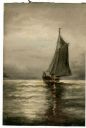
| Description: | Watercolor painting of a sailboat on Lake Mendota. |
| Date: | 1906 |
|---|---|
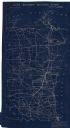
| Description: | This map shows constructed and proposed line of the Lake Superior Southern Railway, as well as other railroads, in the state, a portion of Michigan's Upper... |

| Date: | 1906 |
|---|---|
| Description: | Charles Richter, second from left, poses in front of a building at the top of the Montello granite quarry. His wife stands at the front of the group, weari... |
If you didn't find the material you searched for, our Library Reference Staff can help.
Call our reference desk at 608-264-6535 or email us at: