 Filter: Categories of Wisconsin Historical Images
Filter: FULL_DATE of 1906
Filter: Subject of mississippi river
Filter: Categories of Wisconsin Historical Images
Filter: FULL_DATE of 1906
Filter: Subject of mississippi river
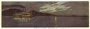
| Date: | 1906 |
|---|---|
| Description: | The sternwheel excursion, "J.S." in the moonlight on the Mississippi River taken in 1906. |
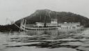
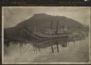
| Date: | 1906 |
|---|---|
| Description: | Side view of the sidewheel packet, Quincy, sinking in 1906. Only her two upper decks are above water. Trempealeau Mountain is in the background. Lat... |
| Date: | 1906 |
|---|---|
| Description: | Sidewheel packet Quincy, sinking. Only her two upper decks are above water. Trempealeau Mountain is in the background. Later renamed the J.S. |
| Date: | 1906 |
|---|---|
| Description: | The Diamond Jo line steamboat Quincy, sunk in 1906 near Trempealeau Mountain, then raised and renamed J.S. |
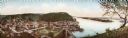
| Date: | 1906 |
|---|---|
| Description: | Bird's-eye view of McGregor on the Mississippi River. |

| Date: | 1906 |
|---|---|
| Description: | A hand-colored map of Wisconsin identifying the railroads, counties, cities, rivers, and lakes in Wisconsin, eastern Minnesota and Iowa, northern Illinois,... |

| Date: | 1906 |
|---|---|
| Description: | A commercial map of Wisconsin showing the location of creameries and cheese factories in the state. In the lower portion of the map provides the number of ... |

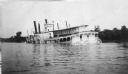
| Date: | 1906 |
|---|---|
| Description: | View across water of an excursion steamboat on the Mississippi River. This image is a part of Frank Feiker's 'Souvenir' series. |
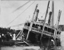
| Date: | 1906 |
|---|---|
| Description: | Group of people stand on pier near the Diamond Jo line steamboat Quincy, sunk in 1906. It was raised and renamed the J.S. There are men on th... |
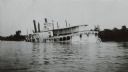
| Date: | 1906 |
|---|---|
| Description: | View across water towards the steamer Quincy, of the Diamond Jo Line, partially sunken into the Mississippi River and listing to port near the shore... |

| Date: | 1906 |
|---|---|
| Description: | This map shows the cities, counties (outlined in yellow and labeled), rivers, lakes, and the major highways and freeways of Wisconsin and parts of the surr... |
If you didn't find the material you searched for, our Library Reference Staff can help.
Call our reference desk at 608-264-6535 or email us at: