 Filter: Categories of Wisconsin Historical Images
Filter: FULL_DATE of 1906
Filter: Subject of cities and towns
Filter: Categories of Wisconsin Historical Images
Filter: FULL_DATE of 1906
Filter: Subject of cities and towns

| Date: | 1906 |
|---|---|
| Description: | This map shows ward boundaries, lot and block numbers and dimensions, house numbers, electric car lines, steam railways, and adjoining plat numbers in a po... |

| Date: | 1906 |
|---|---|
| Description: | This map shows wards, schools, engine houses, railroads, street railways, block numbers, parks, roads, and Lake Michigan. Also included are indexes: Table ... |

| Date: | 1906 |
|---|---|
| Description: | This map shows streets, railroads, land use, public buildings, commercial businesses, and the Menominee River. Depths are shown by gradient tints and sound... |

| Date: | 1906 |
|---|---|
| Description: | This map shows railroads, rivers, bays, channels, shoreline and hydrography around Thunder Bay, Ontario. Depths are shown by soundings, isolines, and tints... |

| Date: | 1906 |
|---|---|
| Description: | This map shows bays, creeks, railroads and rivers. Relief is shown by contours and spot heights. Depths are shown by contours, tints, and soundings. Includ... |
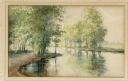
| Date: | 1906 |
|---|---|
| Description: | Watercolor painting of the Yahara River at Lake Monona. |
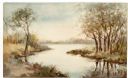
| Date: | 1906 |
|---|---|
| Description: | Watercolor painting of the Yahara River at Lake Monona, with trees in the background and wetlands in the foreground. |
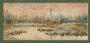
| Date: | 1906 |
|---|---|
| Description: | Watercolor painting of the Yahara River, with large trees on the shoreline. Note: '05 & '06 were the years when Tenney Park and the Yahara River Parkway ... |
| Date: | 1906 |
|---|---|
| Description: | This map shows constructed and proposed line of the Lake Superior Southern Railway, as well as other railroads, in the state, a portion of Michigan's Upper... |

| Date: | 1906 |
|---|---|
| Description: | Charles Richter, second from left, poses in front of a building at the top of the Montello granite quarry. His wife stands at the front of the group, weari... |

| Date: | 1906 |
|---|---|
| Description: | Four large, wood frame houses are seen in this view looking west along Lake Avenue. A small brick house with front bay window is visible through the open p... |

| Date: | 1906 |
|---|---|
| Description: | This map shows the cities, counties (outlined in yellow and labeled), rivers, lakes, and the major highways and freeways of Wisconsin and parts of the surr... |

| Date: | 1906 |
|---|---|
| Description: | Elevated view of the Cedarburg skyline from a bridge over Cedar Creek. There are dwellings in the foreground. Caption reads: "Looking North from Bridge, Ce... |

| Date: | 1906 |
|---|---|
| Description: | Slightly elevated view of a parade on Front Street. Crowds of people are watching from the sidewalks. Caption reads: "Front St., Edgerton, Wis." |

| Date: | 1906 |
|---|---|
| Description: | View of the city hall and church. Both buildings have bell towers. Caption reads: "City Hall and Methodist Church, Evansville, Wis." |

| Date: | 1906 |
|---|---|
| Description: | Elevated view of central Fond Du Lac. Lake Winnebago is in the distance. Churches and other buildings are in the foreground. Caption reads: "Fond du Lac, W... |
| Date: | 1906 |
|---|---|
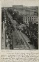
| Description: | Elevated view of Washington Street during a parade. Crowds are lining the street. Caption reads: "Washington Street, Green Bay, Wis." |

| Date: | 1906 |
|---|---|
| Description: | A photocopy of the T.35N, R-8E portion of a map of Lincoln County. |

| Date: | 1906 |
|---|---|
| Description: | View of the water tower. A stable is to the right at the base of the tower on the right. Other buildings are in the background on the left. Caption reads: ... |

| Date: | 1906 |
|---|---|
| Description: | View of the new church. The steeple is on the side near the rear. |
If you didn't find the material you searched for, our Library Reference Staff can help.
Call our reference desk at 608-264-6535 or email us at: