 Filter: Categories of Wisconsin Historical Images
Filter: FULL_DATE of 1906
Filter: Subject of cities and towns
Filter: Subject of water
Filter: Categories of Wisconsin Historical Images
Filter: FULL_DATE of 1906
Filter: Subject of cities and towns
Filter: Subject of water
| Date: | 1906 |
|---|---|
| Description: | View of Madison from Lake Monona with the Wisconsin State Capitol building in the background. This view of Brittingham Park shows a part of the park shortl... |
| Date: | 1906 |
|---|---|
| Description: | Bird's-eye view of McGregor on the Mississippi River. |
| Date: | 1906 |
|---|---|
| Description: | Elevated view from hill towards the Fox River and an industrial area through trees. A powerline is running across the skyline. Caption reads: "View on Fox ... |
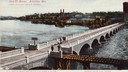
| Date: | 1906 |
|---|---|
| Description: | Elevated view of the bridge, which is intersected by a railroad bridge. Caption reads: "John St. Bridge, Appleton, Wis. Largest stone arch bridge in Wiscon... |
| Date: | 1906 |
|---|---|
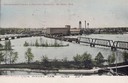
| Description: | Caption reads: "Panoramic View of Fox River, De Pere, Wis." Elevated view of the bridge crossing over the Fox River near De Pere. |
| Date: | 1906 |
|---|---|
| Description: | Elevated view of the bridge over the Fox River at De Pere. Caption reads: "View of Bridge at De Pere, Wis." |
| Date: | 1906 |
|---|---|
| Description: | The caption reads: "'The Dam at De Pere', south of Green Bay, Wis." View of the dam towards the far shoreline, with pedestrians walking on the bridge above... |
| Date: | 1906 |
|---|---|
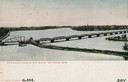
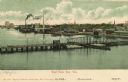
| Description: | Elevated view. Caption reads: "Government Locks & Factory District, De Pere, Wis." |

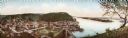
| Date: | 1906 |
|---|---|
| Description: | Elevated view of downtown Eau Claire. |
| Date: | 1906 |
|---|---|
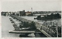
| Description: | Elevated view of Fox River in the river district. Caption reads: "Bird's-eye View of River, Green Bay, Wis." |
| Date: | 1906 |
|---|---|
| Description: | Elevated view of East Green Bay, Fox River, and various buildings belonging to the manufacturing industry. Caption reads: "East Green Bay, Wis." |

| Date: | 1906 |
|---|---|
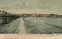
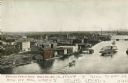
| Description: | View from Fox River of chimneys, buildings, and boat. Caption reads: "River Front, Green Bay, Wis." |

| Date: | 1906 |
|---|---|
| Description: | View from shoreline looking over a pathway towards the Steensland Bridge and Yahara River Parkway at East Washington Avenue. |

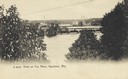
| Date: | 1906 |
|---|---|
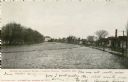
| Description: | View of Lake Mendota Drive at the foot of Stevens Hill. |

| Date: | 1906 |
|---|---|
| Description: | View of Horlick's mill and dam, also known as "Ye Old Mill." |

| Date: | 1906 |
|---|---|
| Description: | Polyconic projection. Map made from surveys without spirit level control. Henry Gannett, Chief Topographer. Topography by Van H. Manning and Nat. Tyler, Jr... |
| Date: | 1906 |
|---|---|
| Description: | Oconto River, looking north. Caption reads: "Scene on Oconto River, Looking North, Oconto, Wis." |
| Date: | 1906 |
|---|---|
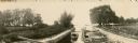
| Description: | A boat full of men and women is entering the lock on the Yahara River at Tenney Park. |
| Date: | 1906 |
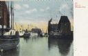
|---|---|
| Description: | Boats on the Milwaukee River. Caption reads: "Boats on Milwaukee River." |
If you didn't find the material you searched for, our Library Reference Staff can help.
Call our reference desk at 608-264-6535 or email us at:
