 Filter: Categories of Wisconsin Historical Images
Filter: FULL_DATE of 1906
Filter: Subject of cities and towns
Filter: Subject of transportation
Filter: Categories of Wisconsin Historical Images
Filter: FULL_DATE of 1906
Filter: Subject of cities and towns
Filter: Subject of transportation
| Date: | 1906 |
|---|---|
| Description: | These maps, which are based on a 1906 survey, show the Wisconsin River from Sugar Bowl Rock, approximately 2 1/2 miles below Wisconsin Dells (labeled Kilbo... |

| Date: | 1906 |
|---|---|
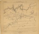
| Description: | Shows railroads, lakes, rivers, cities, and boundaries of zones. "For the Wisconsin Central Railroad Co." Includes longitudial section, 3 cross sections, a... |
| Date: | 1906 |
|---|---|
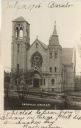
| Description: | Photographic postcard of an elevated view across street of the front of the Catholic Church, which is a large, stone building. There is a belfry on the lef... |
| Date: | 1906 |
|---|---|
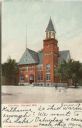
| Description: | Colorized postcard of an exterior view of City Hall, a brick building with an arched entrance, a flag pole on the left, and a belfry on the right. Caption ... |
| Date: | 1906 |
|---|---|
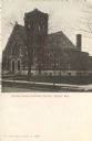
| Description: | Colorized postcard view of the exterior of the Second Congregational Church. Caption reads: "Second Congregational Church, Beloit, Wis." |

| Date: | 1906 |
|---|---|
| Description: | Colorized postcard view of a lock on the Fox River. Caption reads: "The Locks, Berlin, Wis." |
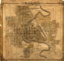
| Date: | 1906 |
|---|---|
| Description: | This map of Stoughton shows plat additions, numbered lots, some land ownership, and labeled streets. The map is color coded in blue, pink, and yellow altho... |
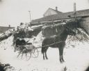
| Date: | 1906 |
|---|---|
| Description: | Winter scene with a man and woman driving in a horse-drawn "cutter" in the snow. They have a fur blanket over their laps. Behind them is a building, perhap... |
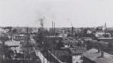
| Date: | 1906 |
|---|---|
| Description: | Elevated view of town with homes and factories. |
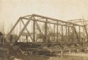
| Date: | 1906 |
|---|---|
| Description: | Steel span railroad bridge under construction over Cedar Creek. |
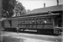
| Date: | 1906 |
|---|---|
| Description: | Eight men and one dog lean their heads outside of the windows of a passenger car caboose of the Chicago, Milwaukee, and St. Paul railway for a group portra... |

| Date: | 1906 |
|---|---|
| Description: | View across unpaved street towards the Hotel Trumpf, located at 636 West Washington Avenue. The entrance is on the corner of the building facing the inters... |
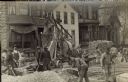
| Date: | 1906 |
|---|---|
| Description: | Traffic to the J. Ohlenforst Bakery at 529 S. Sixth Street, in the Walker's Point neighborhood, is impeded by street construction. There are piles of grave... |

| Date: | 1906 |
|---|---|
| Description: | This topographical map shows the Little Platte River, shafts, test-pits, old workings, contour lines of Galena limestone elevation, railroads, and building... |

| Date: | 1906 |
|---|---|
| Description: | This map shows ward boundaries, subdivisions, lot and block numbers and dimensions, house numbers, electric car lines, steam railways, and adjoining plat n... |

| Date: | 1906 |
|---|---|
| Description: | This map shows ward boundaries, lot and block numbers and dimensions, house numbers, electric car lines, steam railways, and adjoining plat numbers in a po... |

| Date: | 1906 |
|---|---|
| Description: | This map shows wards, schools, engine houses, railroads, street railways, block numbers, parks, roads, and Lake Michigan. Also included are indexes: Table ... |

| Date: | 1906 |
|---|---|
| Description: | This map shows streets, railroads, land use, public buildings, commercial businesses, and the Menominee River. Depths are shown by gradient tints and sound... |

| Date: | 1906 |
|---|---|
| Description: | This map shows railroads, rivers, bays, channels, shoreline and hydrography around Thunder Bay, Ontario. Depths are shown by soundings, isolines, and tints... |

| Date: | 1906 |
|---|---|
| Description: | This map shows bays, creeks, railroads and rivers. Relief is shown by contours and spot heights. Depths are shown by contours, tints, and soundings. Includ... |
If you didn't find the material you searched for, our Library Reference Staff can help.
Call our reference desk at 608-264-6535 or email us at: