 Filter: Categories of Wisconsin Historical Images
Filter: FULL_DATE of 1906
Filter: Subject of cities and towns
Filter: Subject of land
Filter: Categories of Wisconsin Historical Images
Filter: FULL_DATE of 1906
Filter: Subject of cities and towns
Filter: Subject of land
| Date: | 1906 |
|---|---|
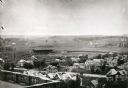
| Description: | Elevated view of Camp Randall Field from the top of Bascom Hall, with University Heights in the background. A crowd is in the stands at the stadium, and a ... |

| Date: | 1906 |
|---|---|
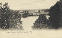
| Description: | Bird's-eye view of McGregor on the Mississippi River. |
| Date: | 1906 |
|---|---|
| Description: | Elevated view from hill towards the Fox River and an industrial area through trees. A powerline is running across the skyline. Caption reads: "View on Fox ... |

| Date: | 1906 |
|---|---|
| Description: | Elevated view of downtown Eau Claire. |
| Date: | 1906 |
|---|---|
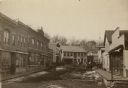
| Description: | View down unpaved street of lined with commercial buildings. Pedestrians are on the sidewalks, and some snow is along the curbs. In the background is a hil... |
| Date: | 1906 |
|---|---|
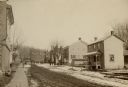
| Description: | View down sidewalk on the left side of an unpaved street. A brick building is in the foreground on the left. Dwellings are along the right, and snow is on ... |

| Date: | 1906 |
|---|---|
| Description: | View from rocky shoreline of a lumber mill on the banks of the Chippewa River. Smoke is coming out from a smokestack. |

| Date: | 1906 |
|---|---|
| Description: | Hand-drawn topographical map of the Turville Estate. |

| Date: | 1906 |
|---|---|
| Description: | Topographical map of Turville Point and lands to the South to Nine Springs Creek. |

| Date: | 1906 |
|---|---|
| Description: | This map of Sheboygan County, Wisconsin, from the early 20th century shows school districts and school locations in the county. Also shown are the township... |

| Date: | 1906 |
|---|---|
| Description: | This 1906 map of Bayfield County, Wisconsin, shows towns, sections, cities, villages and post offices, land ownership, wagon roads, railroads, schools, gov... |

| Date: | 1906 |
|---|---|
| Description: | This map, which shows the Fox River and the likely location of a Mascoutin village near Berlin, Wisconsin, was published in the Proceedings of the State Hi... |
| Date: | 1906 |
|---|---|
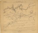
| Description: | These maps, which are based on a 1906 survey, show the Wisconsin River from Sugar Bowl Rock, approximately 2 1/2 miles below Wisconsin Dells (labeled Kilbo... |

| Date: | 1906 |
|---|---|
| Description: | Shows railroads, lakes, rivers, cities, and boundaries of zones. "For the Wisconsin Central Railroad Co." Includes longitudial section, 3 cross sections, a... |
| Date: | 1906 |
|---|---|
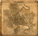
| Description: | This map of Stoughton shows plat additions, numbered lots, some land ownership, and labeled streets. The map is color coded in blue, pink, and yellow altho... |

| Date: | 1906 |
|---|---|
| Description: | This topographical map shows the Little Platte River, shafts, test-pits, old workings, contour lines of Galena limestone elevation, railroads, and building... |

| Date: | 1906 |
|---|---|
| Description: | This map shows streets, railroads, land use, public buildings, commercial businesses, and the Menominee River. Depths are shown by gradient tints and sound... |

| Date: | 1906 |
|---|---|
| Description: | This map shows railroads, rivers, bays, channels, shoreline and hydrography around Thunder Bay, Ontario. Depths are shown by soundings, isolines, and tints... |

| Date: | 1906 |
|---|---|
| Description: | This map shows bays, creeks, railroads and rivers. Relief is shown by contours and spot heights. Depths are shown by contours, tints, and soundings. Includ... |
If you didn't find the material you searched for, our Library Reference Staff can help.
Call our reference desk at 608-264-6535 or email us at:
