 Filter: Categories of Wisconsin Historical Images
Filter: FULL_DATE of 1906
Filter: Subject of cities and towns
Filter: County of Milwaukee
Filter: Subject of streets
Filter: Categories of Wisconsin Historical Images
Filter: FULL_DATE of 1906
Filter: Subject of cities and towns
Filter: County of Milwaukee
Filter: Subject of streets

| Date: | 1906 |
|---|---|
| Description: | Bird's-eye map of South Milwaukee. |
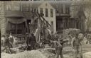
| Date: | 1906 |
|---|---|
| Description: | Traffic to the J. Ohlenforst Bakery at 529 S. Sixth Street, in the Walker's Point neighborhood, is impeded by street construction. There are piles of grave... |

| Date: | 1906 |
|---|---|
| Description: | This map shows ward boundaries, subdivisions, lot and block numbers and dimensions, house numbers, electric car lines, steam railways, and adjoining plat n... |

| Date: | 1906 |
|---|---|
| Description: | This map shows ward boundaries, lot and block numbers and dimensions, house numbers, electric car lines, steam railways, and adjoining plat numbers in a po... |

| Date: | 1906 |
|---|---|
| Description: | This map shows wards, schools, engine houses, railroads, street railways, block numbers, parks, roads, and Lake Michigan. Also included are indexes: Table ... |
If you didn't find the material you searched for, our Library Reference Staff can help.
Call our reference desk at 608-264-6535 or email us at: